Warm And Cold Fronts – What They Are And How They Differ From Each Other
Warm And Cold Fronts – What They Are And How They Differ From Each Other

Frequent viewers of weather forecasts will be familiar with the terms “warm and cold fronts.” Exactly what they are, though, and the differences between the two frontal systems may be more unclear.
The fact that cold fronts are usually closely associated with low-pressure systems, while warm fronts are more commonly associated with high-pressure systems, can create or contribute to some of the confusion that reigns between the two phenomena.
Low-pressure systems are synonymous with cold & wet weather, while high-pressure systems are closely related to warm & dry weather. One can argue that their corresponding frontal systems will have the same characteristics. This is not always the case, though.
By making a direct comparison, but also looking at each meteorological phenomenon separately, it will be easier to gain a better understanding of each frontal system, and how they differ from each other.
The Difference Between A Warm And Cold Front
Both warm and cold front are complex weather systems that require a detailed explanation to properly understand the similarities and differences between the two.
It is important, though, to first gain a clear and concise understanding of the primary difference between the two to establish a proper starting point:
Difference Between A Warm And Cold Front

A warm front occurs on the boundary of a warm air mass moving into a colder region, while a cold front occurs on the boundary of a cold air mass moving into a warmer region. A warm front is typically associated with a high-pressure system, while a cold front is associated with a low-pressure system.
This definition may sound a bit abstract, but some very clear differences set these two advancing air masses apart.
In a nutshell, a cold front is normally characterized by the abrupt arrival of stormy, rainy weather that makes a significant impact on a region. In contrast, a warm front takes longer to build up and usually produces more gentle precipitation for more sustained periods.
This fairly broad statement does not apply to all frontal occurrences. Still, these types of atmospheric conditions are typical behavior of weather generally associated with the arrival of warm and cold fronts.
The two weather systems can further be distinguished from one another by the warmer air that follows in the wake of a warm front, while a body of colder air closely follows the arrival of a cold front.
The cloud type that accompanies each front is also indicative of the kind of frontal system. Warm fronts are associated with uniform low-lying stratus clouds, while cold fronts are accompanied by storm clouds with a significant vertical buildup, like cumulonimbus clouds.
With a basic description of each frontal system out of the way, individually focusing on each weather phenomenon will provide a clearer understanding of the differences and similarities between the two.
Definition Of A Warm Front
The previous section already highlighted the primary differences between warm and cold fronts. However, by taking a more detailed look at a warm front, one will be able to gain a better understanding of why and how these differences occur.
What Is A Warm Front?
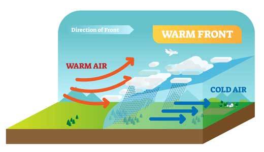 A warm front is the leading edge of a large body of warm air as it advances into a region with cooler air. Warm fronts are closely associated with high-pressure systems and build up over a longer time span, but produce gentler and more sustained spells of precipitation compared to a cold front.
One of the biggest misconceptions about warm fronts is the belief that the weather conditions that characterize the phenomenon are always warm and dry.
Very often, the air following this front is not only warmer but also more humid than the cold air preceding it. This creates the ideal conditions for the formation of gentle and persisting spells of precipitation.
(This type of rain is very welcome in the agricultural sector, where crop growth relies on gentle sustained bouts of rain.)
Warm fronts are also associated with a high-pressure system. As the frontal system approaches, the air pressure drops. However, once the leading edge of the air mass passes over an area, it starts to level off and continues to rise as the air behind it fills the region.

A warm front is further symbolized by a curved red line with semi-circles, which makes it instantly identifiable on any weather map. The semi-circles face the direction in which the front is moving.
Since a warm front moves much more slowly than a cold front, it often happens that the cold front catches up with the warm front, resulting in an occluded front.
Understanding how a warm front develops will help to explain why these frontal systems exhibit the characteristics that make them unique.
How A Warm Front Develops
1. A warm front starts to develop when a body of advancing warmer air encounters a region with colder air.
2. Since warm air is less dense than cold air, it cannot displace it. Instead, the leading edge of warmer mass gradually rises over the boundary of the prevailing cool air.
3. As the air continues to rise on the back of the colder air mass, it starts to cool down until the water vapor can no longer be contained in gaseous form, and condensation takes place.
4. The gentle gradient at which the air rises leads to the formation of uniform stratus clouds that are responsible for producing prolonged spells of soft precipitation.
5. As the warm front passes, the atmospheric conditions are characterized by warmer temperatures and a rise in air pressure.
Definition Of A Cold Front
As is the case with a warm front, one will get a much better understanding of how a cold front works by looking at it in more detail. Before getting to the details, one first needs a clear and concise definition of what a cold front is.
What Is A Cold Front?
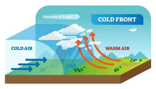 A cold front is the leading edge of a large body of cold air as it advances into a region of warmer air. Warm fronts are closely associated with low-pressure systems. They build up over a relatively short time span but result in more abrupt and severe weather conditions compared to a warm front.
Cold fronts are generally associated with heavy precipitation and stormy atmospheric conditions. Extreme weather conditions such as hail and lightning often accompany the arrival of a cold front.
The air behind a cold front is much denser than the region of warmer air it is moving into. As a result, it quickly lifts the light warm air into the atmosphere, causing it to cool down and condense rapidly.
The rapid lifting and condensation of moist warm air create the ideal conditions for the occurrence of heavy downpours and the formation of thunderstorms.
(These severe weather conditions are characteristic of the arrival of a cold front.)
Cold fronts are also associated with a low-pressure system. As the frontal system approaches, the air pressure starts to drop. The pressure reaches its lowest point as the front passes and then starts to climb in its wake.
How A Cold Front Develops
1. A cold front starts to develop when a body of advancing cold air encounters a region with warmer air.
2. As the frontal system approaches, the air pressure continues to drop. It reaches its lowest point as the front passes and starts to climb again in its wake.
3. Cold air in the frontal system is much denser than the preceding warm air. As a result, the leading edge of the cold front easily pushes underneath the prevailing warmer air, lifting it into the atmosphere.
4. The speed and abruptness with which the warm air is forced to ascend allow for the rapid condensation of water vapor and the formation of storm clouds.
5. This rapid development creates ideal conditions for the creation of heavy downpours and thunderstorms. It is in these storm systems that severe weather conditions such as hail, lightning, and thunder can occur.
6. Air temperatures also start to drop substantially as the cold front approaches, reaching their lowest point as the front passes. It remains cool as the body of cold air moves in behind the leading edge of the frontal system.
The following section draws a direct comparison between a warm and cold front to highlight the specific differences in their development and characteristics.
Warm Front Vs Cold Front
| Warm Front | Cold Front |
|---|---|
| A mass of warm air moves into an area of cooler air. | A mass of cold air moves into an area of warmer air. |
| The warm air cannot displace the denser cold air and gently rises over its boundary. | The cold air is denser than the preceding mass of warm air and displaces it at the surface, forcing it into the atmosphere. |
| Warm fronts are usually associated with high-pressure systems. | Warm fronts are usually associated with high-pressure systems. |
| Accompanied by a rise in temperature. | Accompanied by a drop in temperature. |
| A warm front moves more slowly than a cold front. | A cold front moves faster than a warm front. |
| Associated with a slow and gradual change in weather conditions. | Associated with an abrupt and dramatic change in weather conditions. |
| Characterized by storm clouds with significant vertical buildup like cumulonimbus clouds. | Characterized by more uniform low-lying stratus clouds. |
Conclusion
Warm and cold fronts are two of the most well-known frontal systems used in weather forecasts and viewed by millions worldwide. Other types of fronts, like occluded fronts and stationary fronts, also play a significant role in meteorology but get a lot less attention.
As this article clearly illustrates, both warm and cold fronts have quite a few similarities, but also many major differences in both their development and characteristics.
This post highlighted these similarities but paid specific attention to their differences and what role they play in creating different weather conditions.
Until next time, keep your eye on the weather!