Occluded Fronts – What They Are And How They Occur
Occluded Fronts – What They Are And How They Occur

Frequent viewers of weather forecasts will be familiar with “cold and warm fronts” and their impact on weather events. Few, though, are aware of a meteorological phenomenon known as an occluded front.
Weather conditions often follow and are associated with a specific type of front. Whether your meteorologist discusses cold fronts, warm fronts, or stationary fronts, some atmospheric condition inevitably gets associated with it.
The same principle applies to an occluded front. Unlike the previously mentioned weather systems, occluded fronts are not that well-known. (Similar to a stationary front.) However, this does not mean it is any less important and does not require any less attention.
The focus of this article will be to shed some light on this lesser-known weather front. We examine what an occluded front is and how it is formed, as well as which weather conditions are associated with it.
What Is An Occluded Front?
Before any detail about the formation and associated weather conditions of this occurrence can be discussed, one needs to have a clear understanding of what precisely an occluded front is.
Definition Of An Occluded Front
An occluded front occurs when a cold front moves faster and eventually overtakes a warm front, resulting in the formation of an occluded front through a process called cyclogenesis.
The new front usually develops around the center of a low-pressure system during the formation of a cyclone.
* Cyclogenesis is the term that usually refers to the strengthening of a cyclonic circulation around a low-pressure system. As the name suggests, this phenomenon closely follows the formation and fortification of a type of cyclone.
Although an occluded front is usually the result of the process described in the highlighted section, there is more than just one type of occluded front:
- A Cold Occluded Front develops when the air behind the front is colder, while the air ahead of the front is warmer.
- A Warm Occluded Front, on the other hand, develops when the air behind the front is warmer, while the air ahead of the front is cooler.
The newly-formed front brings with it its unique weather conditions. And even though it doesn’t occur that often, an occluded front still needs to be clearly understood. As a result, it is crucial to explain how an occluded front develops in the first place.
How Does An Occluded Front Form?

For the sake of clarity, we will use the example of an occluded front that forms in the Northern Hemisphere around a low-pressure system as a cold front catches up and overtakes a warm front.
As already stated, the whole process typically takes place during the formation of a cyclonic system. As the circulation around the low-pressure center intensifies, the cold front starts to move faster than the leading warm front.
At some point during the counterclockwise rotation, the cold front catches up and overtakes the warm front. At the point where the two fronts intersect, an occluded front is formed.
At this point, the denser cold air moves in underneath the warm air behind the warm front and meets up with the cold air that was ahead of the hotter system. This process usually leaves a body of cold, dry air trailing in the wake of an occluded front.
What Weather Does An Occluded Front Bring?
Weather conditions do not always manifest themselves in the same way, even when it occurs around the same type of front. Generally, though, certain types of weather patterns can be associated with a specific weather system, which is the case with an occluded front.
One can identify these weather patterns more clearly when looking at the formation of a typical occluded front by using the same example of an occluded front formation used in the previous section.
As the cold front catches up and overtakes the warm front, it pushes underneath and lifts the warm air behind it. Significant precipitation can take place as a result, as the warm air forced upwards, allow the moisture in it to cool down and condensates in water droplets.
It is, therefore, also not uncommon to find the formation of cumulonimbus and nimbostratus clouds along the newly formed front.
Animation showing the development of an occluded front.
The mixing of air behind the cold front with the cooler air in front of the warm front as the two merge causes the air temperatures to drop significantly.
Combined with the majority of moisture lost along the edge of the front due to precipitation, it typically leaves a body of cold and dry air trailing behind an occluded front.
(There are variations, as already described when we explained the difference between a cold and warm occluded front. In the majority of occurrences, though, the weather closely resembles the conditions described in this section.)
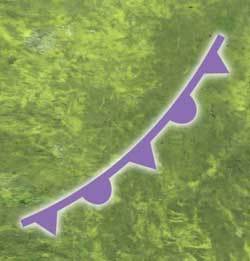
Occluded Front Symbol
![]()
In the section “How Does An Occluded Front Form?”, you can get a good idea of how an occluded front looks on a weather map. As it is the result of a combination of cold and warm fronts, it is common to see the three fronts in the pattern you see displayed in this post.
On its own, the symbol for an occluded front consists of a purple line with alternating triangles and semi-circles. (It effectively combines the triangles of a cold front with semi-circles of a warm front.) They always point in the direction the front is moving.
Conclusion
An occluded front is just one of many lesser-known weather systems at work in the more extensive collection of mechanisms that drive weather and climate around the world.
By now, you will have a clear understanding of what an occluded front is, how it is formed, and what type of weather you can associate with this phenomenon.
It may not occur as often as cold, warm, or stationary fronts, but that does not make it any less critical. The more you know about even the smallest aspect of weather, the better you will be equipped to understand the bigger picture, which is our global weather system.
Until next time, keep your eye on the weather!