Defining Mammatus Clouds – What They Are And How They Form
Defining Mammatus Clouds – What They Are And How They Form

Many cloud formations manage to put on a striking visual display. Mammatus clouds, on the other hand, look very ominous and threatening. This article takes a closer look at these cloud types and their characteristics.
It is very hard not to notice this unique cloud formation, with its pouch-like protrusions extending from the base of a storm cloud. Their appearance also makes them easy to distinguish from other cloud types.
But what exactly are these meteorological phenomena, what causes their very recognizable shape and features, and are they really as dangerous as they appear?
We examine exactly what mammatus clouds (also known as bubble clouds) are, how they form, and the characteristics and features that define them.
What Are Mammatus Clouds?
Before one can start taking a closer, more in-depth look at the characteristics of mammatus clouds and the different ways in which they develop, a more detailed definition of this phenomenon is required:
Mammatus Clouds Definition

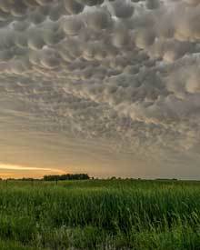
Mammatus clouds are defined as pouch-like structures that typically form below the base of a cumulonimbus cloud formation. They form due to cold sinking air and predominantly consist of ice. They pose no threat themselves but can serve as a precursor for adverse weather conditions.
These formations can stretch for hundreds of miles, and although they pose no threat themselves, they are commonly associated with adverse weather conditions like thunderstorms and tornadoes.
The word “mammatus” is derived from the Latin word “mamma,” which translates to “breast” or “udder.” This is a very apt description, especially when looking at the physical appearance of this cloud formation.
As the title alludes, mammatus clouds are informally or more commonly known as bubble clouds due to their appearance. They are officially known as mammatocumulus.
Technically, mammatus clouds are not individual types of cloud species. Rather, they are an extended feature of the cloud on which they are based.
 Although they are predominantly associated with storm clouds like cumulonimbus, they can also form at the base of other types of clouds like altostratus and stratocumulus. They are also known to form at the base of volcanic ash clouds.
Mammatus clouds can spread out over hundreds of miles during a single event. Although the multiple clusters of lobes that constitute this formation can last anything from 15 minutes to a couple of hours, a single lobe typically lasts for an average of 10 minutes.
What makes mammatus clouds especially unique is not their appearance but rather their development, which is the inverse of normal cloud development. Clouds typically form when rising moist air reaches the dew point, and condensation occurs, which leads to cloud development.
On the contrary, mammatus clouds form as a result of sinking cold air that has enough momentum to continue descending until it passes through the cloud base of a cumulonimbus cloud and develops below it in the familiar “pouch-shaped” structures.
Mammatus Clouds Formation
A few common facts are known about mammatus cloud formation. We know that they form underneath the base of cloud formations, predominantly cumulonimbus clouds.
They also typically form in the presence of unstable air conditions where cold sinking air is directly responsible for their development. (Due to these unstable air conditions associated with these clouds, pilots keep their aircraft well clear of any mammatus cloud development.)
Apart from these well-established facts, very little is known about how these unique clouds form. There is much debate about their origin, and although many theories are in circulation attempting to describe their formation, most are fundamentally flawed.

Illustration showing where mammatus structures develop in a cumulonimbus cloud formation.
The predominant theory that is most widely accepted proposes that saturated cold air in a cumulonimbus starts to spread out once it reaches the tropopause, where a temperature inversion prohibits it from rising any further.
As a result, it starts to spread out horizontally in the anvil part of the cloud. The saturated air is heavier than the surrounding dry air and starts to descend. If enough momentum is present for the air to continue its descent, it emerges as mammatus below the cloud base.
The bottom line is that there is no clear explanation for mammatus cloud development, and their origins remain a mystery.
Mammatus Clouds Facts
Some of the information in this section already appears elsewhere in this article and is explained in more detail, but the following list highlights the key facts and characteristics that define mammatus clouds:
-
- Mammatus clouds are pouch-like structures that typically form below the base of a cumulonimbus cloud formation.
- They are the result of cold sinking air and predominantly consist of ice.
- Although many theories and hypotheses exist, their development remains largely unknown.
- Although they appear ominous and threatening, mammatus clouds pose no threat themselves.
- Since they predominantly appear at the base of cumulonimbus clouds, they are associated with adverse weather conditions like thunderstorms, hail & tornadoes.
- Contrary to popular belief, mammatus clouds do not result in the formation of tornadoes.
- The multiple clusters of lobes that constitute mammatus formations can stretch out over hundreds of miles.
- A mammatus cloud formation can last anything from 15 minutes to a couple of hours, but a single lobe only lasts an average of 10 minutes.
- Although predominantly associated with cumulonimbus clouds, mammatus formations can also be found at the base of other cloud types like altocumulus, altostratus, and cirrocumulus clouds.
- Mammatus clouds can also form underneath ash clouds during a volcanic eruption and have even been known to develop in the contrails of jet airliners.
- In contrast to regular cloud development, which is the result of rising warm air, mammatus clouds are the result of cold sinking air.
- These unique cloud formations have been a favorite subject for photographers and artists alike, and paintings of mammatus clouds date back to the 1500s.
Although by no means an exhaustive list of all aspects involving this meteorological phenomenon, this list captures the most important defining characteristics of mammatus cloud structures.
Are Mammatus Clouds Dangerous?
Although their appearance may seem ominous and threatening, mammatus clouds are not dangerous themselves. However, they are often associated with severe weather events such as thunderstorms, which can produce hazards like strong winds, hail, and lightning.
Conclusion
It is clear that mammatus clouds are some of the most unique and fascinating cloud structures. Their large pouch-like protrusions make them look ominous and threatening, but as this article illustrates, they are completely harmless themselves.
And although their origins remain a mystery and a source of much debate, it has been established that these upside-down formations are the result of cold sinking air and typically form underneath the base of cumulonimbus clouds.
This article defined what mammatus (bubble clouds) formations are, highlighted their key characteristics, and also looked at their development.
Until next time, keep your eye on the weather!