
We often briefly glance at the skies in the morning to see how cloudy it is before heading off to work, school, or college. However, different cloud types can tell us more about the weather than we may think.
Some types of cloud systems can look almost identical to the casual observer. To be honest, it can even be confusing for some seasoned weather enthusiasts.
And to make things more confusing, you have the odd occasion where you experience light rain or drizzle without a cloud in sight. This phenomenon is called a sunshower or serein.
After doing some research, one will also find several different classification systems used for categorizing or grouping different types of clouds together.
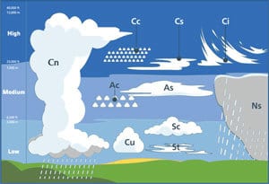
The form of classification that makes the most sense and is widely accepted in the meteorological community, is the one we will focus on in this article.
This system categorizes clouds according to their height in the atmosphere. There are a total of four main groups with the ten major cloud systems organized within each group.
I will name and list the four different cloud groups first, including the ten cloud systems associated with each group. We will then proceed to examine each cloud system with their unique characteristics and features.
The 4 Categories Of Clouds And The 10 Cloud Types Associated With Each One
As I already mentioned, the main four cloud groups are categorized according to their height, with the ten major cloud systems listed below the category they are associated with:
1) High Clouds
- Cirrus
- Cirrocumulus
- Cirrostratus
2) Middle Clouds
- Altocumulus
- Altostratus
3) Low Clouds
- Stratus
- Stratocumulus
4) Multi-level Clouds (Clouds with a large vertical buildup)
- Cumulus
- Cumulonimbus
- Nimbostratus
Now that you have a clear idea what the four main cloud groups are, as well as the ten major clouds and which group they are associated with, we can start to focus in more detail on each group and cloud system.
High Clouds
Clouds are classified as high clouds when they occur at altitudes of 6096 meters (20 000 feet) or higher. At these heights temperatures are below freezing point, meaning the water moisture in the clouds is in the form of ice crystals or supercooled water droplets.
(Supercooled water droplets are water that remains in liquid form below freezing point. Upon contact with ice crystals or any other object like dust or pollen, however, they immediately freeze into crystal form.)
Due to the height of these clouds, they don’t produce precipitation of any kind on their own. They are, however, sometimes seen as early indicators of stormy weather to follow later.
The clouds most commonly found at this height are Cirrus, Cirrocumulus, and Cirrostratus clouds:
1) Cirrus Clouds
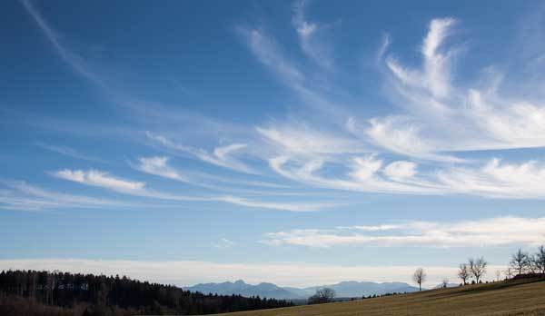
Cirrus clouds are the familiar thin, feathery looking clouds you see high up in the sky on an otherwise clear and sunny day. Some parts of these flaky clouds have an almost transparent look due to their light nature.
As is common with many high-level clouds, they always occur in during clear and pleasant weather conditions. However, as I already pointed out, they may be early indicators of stormy weather or warm fronts.
2) Cirrocumulus Clouds

Cirrocumulus clouds are a variation of Cirrus clouds. They are patchy looking clouds which are often arranged in rows. Some meteorologists see them as a degraded form of Cirrus clouds.
These high-altitude clouds are small and very short-lived and are sometimes referred to as cloudlets. As with Cirrus clouds, they appear and are associated with clear and pleasant weather conditions.
3) Cirrostratus Clouds
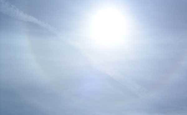
Cirrostratus clouds can be best described as a transparent veil of clouds. Unlike the two previously mentioned high-level clouds, they have a very smooth appearance.
The veil of milky looking clouds can sometimes cover almost the entire sky. Due to the refraction of light by ice crystals, these clouds form the rainbow-colored halos we often see forming around the sun.
These clouds are an indication of high moisture levels in the upper atmosphere, which often precedes the arrival of a warm front.
Middle Clouds
Middle clouds usually occur at altitudes of between 2000 meters (6 500 feet) and 6096 meters (20 000 feet).
As they appear much lower in the atmosphere, some condensation forms above water’s freezing point. This means middle clouds contain a mixture of ice crystals and water droplets.
Apart from appearing lower in the atmosphere, they are also denser than higher-level clouds. This means they are less prone to being transparent and allowing sunlight through.
Middle clouds seldom produce any rainfall. They do, sometimes, create what is called Virga. (Virga is rain or snow that starts falling but evaporates before reaching the ground).
4) Altocumulus Clouds
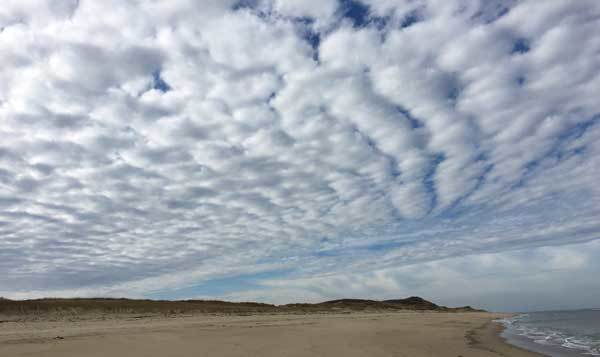
Altocumulus clouds are a very common sight across the world. They are characterized by their woolly, round/oval shaped appearance. These patchy clouds have a white to light grey appearance and are sometimes formed in parallel rows.
Often observed during warm and humid mornings in the middle atmosphere, these clouds can signal the onset of thunderstorms or cold fronts. The time of year and your location will determine the type of weather to expect.
5) Altostratus Clouds
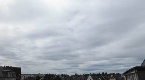
The uniform, grey blanket of cloud cover that often fills the entire sky, is a trademark feature of Altocumulus clouds.
These mid-level clouds are much denser than the similar shaped Cirrostratus clouds found higher up in the atmosphere, meaning they are less transparent and don’t allow shadows to be cast on the ground. They are still thin enough to be able to see the sun through them.
Altostratus clouds are frequently associated with light rain, but due to their height and density, they are not able to produce heavy rains.
Low Clouds
Low clouds are formed at altitudes of below 2000 meters (6 500 feet). At these lower heights, the clouds consist mainly of water droplets.
(Cold winter months with subzero temperatures are the exception when you will find ice crystals present in these low-altitude clouds.)
6) Stratus Clouds
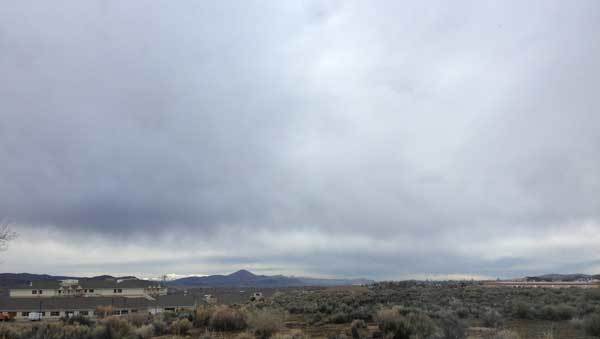
Stratus clouds are made up of thin layers of clouds that are formed close to the ground. They are mostly featureless with a grayish color.
One of their standout features is taking up large portions of the sky at a time. (Often stretching from horizon to horizon.)
Stratus clouds are closely related to fog. In fact, fog is nothing more than a form of stratus cloud that forms at ground level.
The precipitation associated with these dreary looking clouds mostly consists of mist or a light drizzle.
7) Stratocumulus Clouds
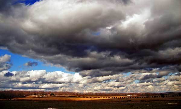
These low-lying, puffy looking clouds are spaced closely together, with small pieces of blues sky visible in between them. When viewed from below they have a honeycomb appearance.
With colors ranging from white to grayish, and their tendency to cover substantial parts of the sky, people often associate rain with these clouds.
In reality, stratocumulus clouds are pretty benign when it comes to precipitation. A light drizzle may be the most you will get out of this cloud system.
Multi-level Clouds
Multi-level Clouds are clouds that have a large vertical buildup. They are called multi-level clouds because of their ability to spread through the lower, middle, and upper cloud levels.
The clouds are characterized by vertical air movements called updrafts. These vertical currents can spread moisture upwards through the cloud system into the upper regions of the atmosphere.
The combination of updrafts and downdrafts in multi-level clouds creates an environment that can result in severe weather events. This includes heavy rainfalls hailstorms and even tornadoes that are formed within multi-level clouds.
Not all multi-level clouds develop to this extent though and can be completely benign, as our first example will illustrate.
8) Cumulus Clouds
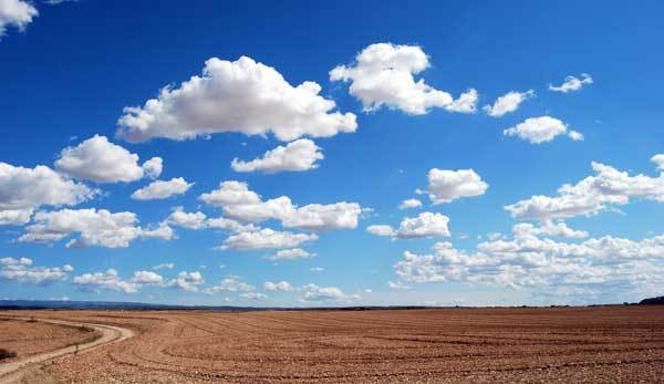
The light, puffy looking clouds scattered across the sky, are arguably the most well-known of all the clouds. (It’s probably the first image that comes to mind when you think of a cloud.)
They are instantly recognizable with their white, fluffy round tops and flat bottoms. They are fairly evenly spread out with a fair amount of blue skies visible between them. (Their shape is often compared to that of a cauliflower.)
Cumulus clouds appear during sunny days early in the day and disappear towards the evening. With no precipitation associated with them, they are often referred to as “fair weather clouds”.
9) Cumulonimbus Clouds

Starting out as a humble cumulus cloud, strong vertical air movement (updrafts) combined with enough humid air allow this type of cloud to develop. Cumulonimbus clouds are seen as your typical storm clouds.
They start at a low cloud level and can grow and expand up to the highest level. It is within this space, dominated by updrafts and downdrafts, that all the elements necessary for the development of a storm system are formed.
When viewed from a distance, cumulonimbus clouds appear to have a low dark base, with the clouds above it building up to great heights, creating a spectacular towering effect.
The lower levels of a cumulonimbus cloud consists mainly of water droplets, while the upper level, where temperatures are well below zero, mainly consists of ice crystals and supercooled water.
As far as precipitation goes, these clouds are known for producing heavy rainfall and hailstorms. They are also responsible for producing violent winds, and it is within this cloud system that tornadoes can occur.
10) Nimbostratus Clouds
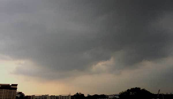
Nimbostratus clouds typically cover the entire sky. It is a dark, thick layer of clouds, capable of completely blotting out the sun.
Starting at a low level and building up in height, the clouds are usually loaded with moisture and associated with long periods of persistent rain or snowfall. That is why it is known as your typical rain cloud, with the precipitation usually spread out over a large area.
Alongside cumulonimbus clouds, nimbostratus clouds are almost guaranteed to provide the area it covers with a substantial amount of precipitation.
However, they do not have the uniquely identifiable shape of cumulonimbus clouds, and it’s harder to judge where the rainfall will take place due to the large area it covers.
Conclusion
Breaking it up into proper categories helps you to better distinguish the different clouds from one another. You should now be able to start telling the major cloud systems apart.
You will be forgiven for still finding it difficult to tell certain clouds apart. Some of them are almost indistinguishable under some conditions. Even experienced still have a hard time sometimes telling them apart.
But you know what they say, “Practice makes perfect”.
In a separate article, I go into a little more detail and take you through the steps to help you identify cloud systems. I also explain how you can use your cloud knowledge alongside your home weather station to make better forecasts. You can find that article here.
Never miss out again when another interesting and helpful article is released and stay updated, while also receiving helpful tips & information by simply clicking on this link .
Until next time, keep your eye on the weather!

