Regular viewers of weather forecasts will be very familiar with cold and warm fronts. A lesser-known frontal system known as a stationary front doesn’t receive as much attention but is of no less importance.
A stationary front is a frontal system that forms at a fixed location when two air masses meet, but neither is strong enough to replace the other. If one air mass gains strength or the wind direction changes, it starts to move again as either a cold or warm front, depending on the dominant air mass.
Normally, either cold or warm fronts dominate any weather discussion or forecast. Two other frontal systems, the occluded and stationary fronts, don’t get mentioned that often but still play a significant part in determining weather conditions.
(Learn all about an occluded front, how it forms, and the weather conditions associated with it in this article.)
This post will examine what a stationary front is, how it develops, as well as looking at the type of weather generally associated with this front.
What Is A Stationary Front?
As is the case with all other fronts, we first need to have a clear definition of precisely what a stationary front is before one can look at its other characteristics.
What Is A Stationary Front?

A stationary front is a frontal system that forms at a fixed location when two air masses come together, but neither is strong enough to replace the other.
If one air mass gains strength or the wind direction change, the front starts moving again as either a cold or warm front, depending on the dominant air mass.
Although a stationary front remains in one position, it doesn’t mean that weather conditions and air movement around it come to a standstill as well. As you will see in the following sections, there is plenty of weather activity along and on both sides of a stationary front.
How Does A Stationary Front Form?

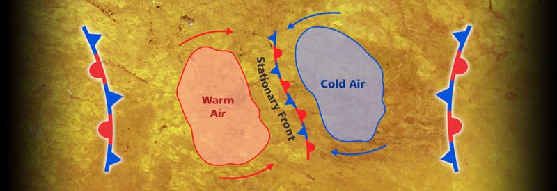
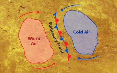
The formation of a stationary front. Click on the image for a larger view.
As already stated in the definition, a stationary front forms when two air masses meet, but neither one of the two is strong enough to displace the other. (It usually occurs when a cold front and warm front catch up with each other.)
This stalemate leads to the development of a stationary front that remains in one location, sometimes for days on end. It can lead to extended periods of dreary and miserable weather, as you will discover in the next section.
Eventually, the front can start moving again as a result of one of the two air masses gaining strength or a change in wind direction occur. The new forward-moving front can be a cold or warm front, depending on which of the air masses gained more strength.
A stationary front can also eventually break up and dissipate entirely or develop into shear lines. The latter usually occurs over a large open area like the ocean.
What Weather Does A Stationary Front Bring?
The weather that accompanies a stationary front is not nearly as dormant as the movement of the front itself. It is not uncommon to find winds blowing parallel to the direction of a stationary front.
Another characteristic of a stationary front is the distinct difference in temperature experienced on either side of this “fixed barrier.” The mass of air behind the approaching warm front has a much higher temperature than the mass of air behind the approaching cold front.
A stationary front is also often accompanied by overcast and dreary weather with persistent light precipitation that can last for days. This condition usually depends on the amount of moisture present in the air.
On occasion, a stationary front can lead to extreme events. When a high percentage of moisture is present in the atmosphere, heavy & persistent rain can lead to flooding in the region along the front.
Heavy winds called Derechos sometimes develop due to strong downdrafts along the border of a stationary front. They can reach speeds of 160 km/h (100 miles per hour), which can cause damage to infrastructure and endanger human life.
Stationary Front Symbol
In the section, “How Does A Stationary Front Form?”, you can get a good idea of how a stationary front looks in context and how it may be depicted during a weather forecast.

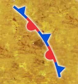
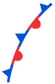
The symbol for a stationary front consists of a series of interconnecting blue and red sections. Each section has a corresponding triangle or semi-circle, which also alternates with every transition from one segment to the other.
The blue section represents the colder air mass with the same blue triangle, which you will find on the symbol representing an actual cold front. The triangles also point towards the direction in which the cold air is trying to move.
The red section represents the warmer air mass with the same red semi-circles, which you will find on the symbol representing an actual warm front. The semi-circles also point towards the direction in which the warm air is trying to move.
Don’t confuse the symbol representing a stationary front with the one indicating an occluded front. Both consist of a series of alternating triangles and semi-circles.
A single homogeneous purple-colored symbol indicates an occluded front. A stationary front, however, is represented by the symbol with alternating red and blue colors, as seen in this article and section.
Conclusion
From the four major weather fronts, the stationary front is the least well-known, together with the occluded front. However, as you have seen throughout this article, it has a significant impact on weather conditions.
You now know what a stationary front is and how it is formed. And you also know what type of weather conditions to expect in its vicinity.
Never miss out again when another interesting and helpful article is released and stay updated, while also receiving helpful tips & information by simply clicking on this link .Until next time, keep your eye on the weather!
Also Read

