Continental Arctic To Maritime Equatorial… The Six Types Of Global Air Masses And Their Characteristics
Continental Arctic To Maritime Equatorial… The Six Types Of Global Air Masses And Their Characteristics

Six types of global air masses cover the Earth’s surface and impact the weather patterns of individual regions. We take a closer look at each one and its main characteristics.
Six Primary Types Of Global Air Masses
1 Continental Arctic (cA) / Continental Antarctic (cAA)
2 Continental Polar (cP)
3 Maritime Polar (mP)
4 Continental Tropical (cT)
5 Maritime Tropical (mT)
6 Maritime Equatorial (mE)
At any given time, all regions throughout the world are covered with vast bodies of air. Each one has its specific atmospheric conditions that define the weather in the area it covers.
Depending on multiple factors, any country can experience more than one air mass. It is not just due to its location, which may lie on the boundary between different air masses, but also as a result of prevailing winds that can move air masses from their position.
This article explores what an air mass is, looks at its characteristics, and then provides an in-depth explanation of the different types of air masses.
Air Mass Definition
The climate of any region in the world is largely determined by observing the characteristics of the air mass that occupies it. (Weather can cause short-term atmospheric changes, but the stable air mass determines the prevailing weather conditions of a vast territory.)
Before we examine the major air masses that cover the globe in more detail, one needs first to gain a clear understanding of what precisely an air mass is:
What Is An Air Mass?
Air mass is the meteorological term for a volume of air with a constant temperature and humidity covering an area. It varies in size from hundreds to thousands of miles. It remains positioned over a region for extended periods and, as a result, takes on the characteristics of the surface it covers.
These vast bodies of air that spread out horizontally for up to thousands of miles are separated from one another by weather fronts. It is in and around weather fronts on the boundary between air masses that the majority of meteorological activity takes place.
The characteristics of the kind of weather that occurs on the border between air masses depend on the type of weather front present. Weather fronts vary from the more familiar cold and warm fronts to the less familiar stationary and occluded fronts.
(You can learn more about a cold and warm front and their associated weather in this article. You can learn all about a stationary front here and get in-depth information about an occluded front in this post.)
The region over which an air mass forms is called a source region. This region can be a land surface or a body of water.
Although air masses spread out horizontally over large distances, they can also reach high altitudes with heights of up to 16 km (10 miles), well into the stratosphere.
Types Of Air Masses
A number of classification systems exist to categorize the major global air masses. Of them, the Bergeron Classification System has been the most widely acknowledged and adopted.

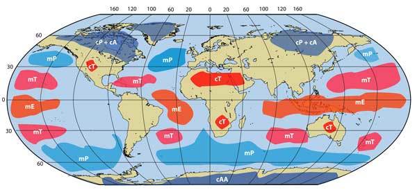
Global Air Masses: Continental Arctic/Antarctic (cA/cAA), Maritime Polar (mP), Continental Polar (cP), Maritime Tropical (mT), Continental Tropical (cT), and Maritime Equatorial (mE)
According to this system, the classification of air masses first takes place according to the source regions from where they originate. There are four central regions classified according to their latitude:
- Arctic/Antarctic Air Mass
- Polar Air Mass
- Tropical Air Mass
- Equatorial Air Mass
A capitalized initial identifies each of these regions. It means A stands for Arctic/Antarctic, P stands for Polar, T stands for Tropical, and E stands for Equatorial.
But the source region is not the only factor that determines the attributes of an air mass. The amount of moisture in an air mass also plays a significant role in forming its characteristics, which is primarily the result of the type of surface over which it occurs.
Two types of surfaces have the most significant influence on moisture levels:
- Continental
- Maritime
Continental surfaces point to landmasses like continents, while maritime surfaces refer to bodies of water. The lowercase initial of each type of surface gets placed in front of the capitalized initial of the source region when identifying a landmass.
For example, “mP” refers to Maritime Polar, while “cT” refers to Continental Tropical.
(A third lowercase letter sometimes gets placed at the end of the first two to create an even more accurate description of an air mass. “k” refers to an air mass that is colder than the surface below, while “w” refers to an air mass warmer than the underlying surface.)
Six primary types of air masses covering the planet emerge when you combine the source region with the kind of surface underlying an air mass:
- Continental Arctic (cA) / Continental Antarctic (cAA)
- Continental Polar (cP)
- Maritime Polar (mP)
- Continental Tropical (cT)
- Maritime Tropical (mT)
- Maritime Equatorial (mE)
The abbreviation for each primary air mass is noted next to the full description. As described, the first lowercase letter indicates the type of surface, while the second uppercase letter represents the source region of the air mass.
The influence of both the source region and the type of surface is evident in the characteristics of any overlying air mass. This will quickly become clear as one takes a closer look at each of the primary air masses:
Continental Arctic / Continental Antarctic Air Mass

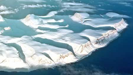
The Continental Arctic (cA) Air mass develops over the ice-covered regions of the North Pole and Greenland. It mainly takes place over the ice and snow covering the area and therefore is classified as continental.
This air mass only takes place during the winter when solar radiation during the day is almost nonexistent. The icy conditions, combined with a lack of moisture, create very cold and dry atmospheric conditions.
It’s no surprise then that the Arctic Air Mass is colder than other types of air masses.
The Continental Antarctic (cAA) Air Mass develops solely over the continent of Antarctica. Since it only develops over land, it is also classified as continental.
The air is extremely dry and cold as a result of the icy surface and lack of moisture. It is the coldest of all air masses, including the Arctic Air Mass, no matter the time of year or season.
Continental Polar Air Mass
Continental Polar (cP) Air Masses develop over the landmasses of subpolar regions. They primarily affect areas at high latitudes like Canada, the Northern United States, as well as Northern Asia.
It is characterized by cold, dry weather with little cloud cover and precipitation, especially during the winter. The high-pressure system that exists over a region experiencing a Continental Polar Air Mass allows for a very stable body of air.
When it moves south, these air masses start to change as they move over warmer surfaces and are subjected to longer and more intense periods of solar radiation. In return, it can provide a pleasant reprieve from warm weather during the summer months.
Maritime Polar Air Mass
Maritime Polar (mP) Air Masses form over the freezing North Atlantic and Pacific Oceans near the Arctic. As a result, they are characterized by cold, moist, and unstable weather.
When it originates directly over the water, the air mass can influence adjacent coastlines. For example, the polar air that originates over the North Atlantic has a significant effect on the northeastern part of the United States.
Maritime Polar Air Masses can also start over land and move over a body of water. The continental polar air over Asia moves east over the North Pacific, where it picks up moisture from the surface and develops into a Maritime Polar Air Mass.
The moisture content in this form of air mass is less than the moisture found in Maritime Tropical Air Masses.
The precipitation associated with Maritime Polar Air is characterized by light but persistent drizzles or rain showers. Depending on the season and severity, it can also produce more moderate showers as well as snowfall.
The air mass impacts the temperatures of the adjacent coastlines differently throughout the year. During the summer, it brings cooler air to the land, while the moderate air mass warms the coastal and border regions during the cold winter months.
Continental Tropical Air Mass

Continental Tropical (cT) Air Masses form approximately 25 degrees north and south of the Equator over the dry, mostly arid regions of the world. It mainly occurs over deserts, including the Sahara, the deserts of Mexico, Australia, and the Arabian Peninsula.
As a result of the source region and low latitude, Continental Tropical Air Masses are characterized by hot and dry weather conditions.
Due to the nature of desert weather, temperatures drop as sharply in the evenings as they rise during the day, leading to extreme contrasts in atmospheric conditions.
Continental Tropical Air Masses are often associated with prolonged dry weather conditions, which can lead to severe droughts in affected regions. Similarly, extreme weather phenomena like heatwaves are also more prone to occur in these atmospheric conditions.
Maritime Tropical Air Mass
As the name suggests, Maritime Tropical (mT) Air Masses mainly occur over the warm oceans of the Tropics and Subtropical Regions. They cover vast areas of the South Atlantic, Indian, and South Pacific Oceans.
With their location near the Equator (with its high levels of incoming solar radiation), combined with the ocean surface, Maritime Tropical Air Masses are characterized by very hot and humid weather conditions.
They are responsible for a large part of the cloud cover and precipitation in neighboring landmasses. In the United States, a large percentage of the country’s rainfall is the result of Maritime Tropical Air. It is also responsible for the majority of the country’s thunderstorms.
(It is also the most dominant air mass over the United Kingdom and is responsible for a large percentage of the country’s precipitation.)
Maritime Equatorial Air Mass

Air Masses at or near the Equator primarily form over water, and as a result, are all referred to as Maritime Equatorial Air Masses. (The small portions of land that it covers consist mostly of rainforests and not exposed dry land.)
Due to the surface and latitude over which they form, these air masses are hot and very humid. The high moisture levels in the air mass are responsible for the large volume of precipitation that occurs over land in the region.
For example, the rainforests of Central Africa and the Amazon in South America receive high volumes of rainfall throughout the year as a result of the Equatorial Air Mass.
Air Mass Facts
The following list has been compiled to assist in summarizing and highlighting the essential facts about air masses and their characteristics.
- An air mass is a large volume of air with a constant temperature & humidity that covers vast regions and remains stationary over an area for prolonged periods.
- Air masses are separated from one another by a weather front.
- The area/latitude where an air mass originates from is called the source region.
- The four source regions where air masses form according to latitude are the Equatorial (E), Tropical (T), Polar (P), and Arctic (A) regions.
- Air masses are also classified according to the type of surface underlying it, which can be continental (c) or maritime (m).
- Continental Arctic (cA) Air Masses are characterized by very cold & dry weather.
- Continental Polar (cP) Air Masses are characterized by cold & dry weather.
- Maritime Polar (mP) Air Masses are characterized by cold & moist weather.
- Continental Tropical (cT) Air Masses are characterized by hot & dry weather.
- Maritime Tropical (mT) Air Masses are characterized by hot & moist weather.
- Maritime Equatorial (mE) Air Masses are characterized by hot & very moist air.
Each of these key facts is fully covered and explained in previous sections of this article. You can find more information on each topic by simply following the appropriate heading.
Conclusion
This article clearly illustrated the importance of the world’s air masses. They play a crucial role in the formation of the weather and climate patterns that we attribute to different regions and countries throughout the year.
Each air mass is clearly defined and differentiated from one another by the source region from where it originated, as well as the type of underlying surface (land or water). This became evident while describing the characteristics of each of the major air masses.
This post described what an air mass is, how it forms, and also went on to explain the different types of air masses and their attributes in more detail.
Until next time, keep your eye on the weather!


