The Coriolis Effect – What It Is And How It Affects Our Weather
The Coriolis Effect – What It Is And How It Affects Our Weather
Although some readers will be familiar with the Coriolis Effect, others may never have heard of this meteorological occurrence. We examine this phenomenon, what it is, and its impact on weather and climate.
The Coriolis Effect is so important, in fact, that it influences almost every significant weather event occurring around the world. And it all directly results from the Earth’s rotation:
The Coriolis Effect is caused by the Earth’s rotation from west to east. This causes a deflection in air movement as it travels away from Polar & Equatorial regions, respectively.
This phenomenon is responsible for the formation of some of the world’s largest weather systems like hurricanes, typhoons, and tropical storms, as well as repeating circulating air masses like Trade Winds.
The principle may sound simplistic, but understanding it is a bit more complex. If one simply tries to put it into words, it won’t make sense. For this reason, we will use an analogy alongside the appropriate illustrations to explain the principle in practice.
We will then continue and illustrate how it applies to the Earth’s rotation and influences weather systems and events wherever they form on the planet.
What Is The Coriolis Effect?
The introduction already provided a brief description of what the Coriolis Effect is. Before continuing, though, one first needs a more concise and detailed definition:
Coriolis Effect Definition
The Coriolis Effect primarily describes the apparent deflection caused by Earth’s eastward rotation, resulting in air movement being deflected to the right in the Northern Hemisphere and to the left in the Southern Hemisphere. It is one of the primary driving forces of global wind patterns and weather events.
How The Coriolis Effect Works
To best understand the Earth’s rotation and the resulting influences on global wind movements, the analogy of a playground merry-go-round will be used.
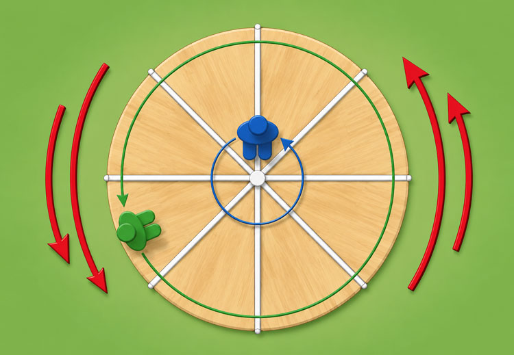
You can use the illustration above to better understand the process. The merry-go-round is viewed from the top to best explain how the Coriolis Effect works.
Imagine the merry-go-round is spinning counterclockwise at a rapid speed. On the platform, the people in green and blue would both have completed one full rotation as the merry-go-round completed one rotation.
But (as all of us who have been on a merry-go-round will know), the green figure would have travelled much faster and covered a greater distance than the blue figure sitting closer to the centre of the merry-go-round in the same period of time.
When viewed from the top, the Earth works in exactly the same way. This means the blue figure will represent the two polar regions, while the green figure represents the tropical regions.
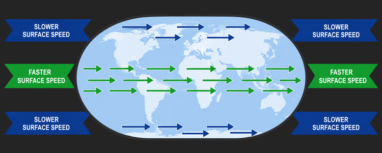
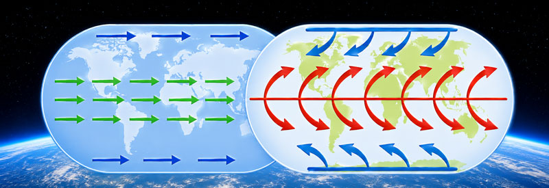
Now let’s flip the map sideways as we would normally view a map of the world (as illustrated in the image above). The same principle explained in the previous section still applies, but from this view, the Coriolis Effect can be much better explained and understood.
It is important to note that the speed of rotation in the tropics (indicated in green) is much faster than the speed of rotation at the poles (indicated in blue). This is the main driving force of the Coriolis Effect.
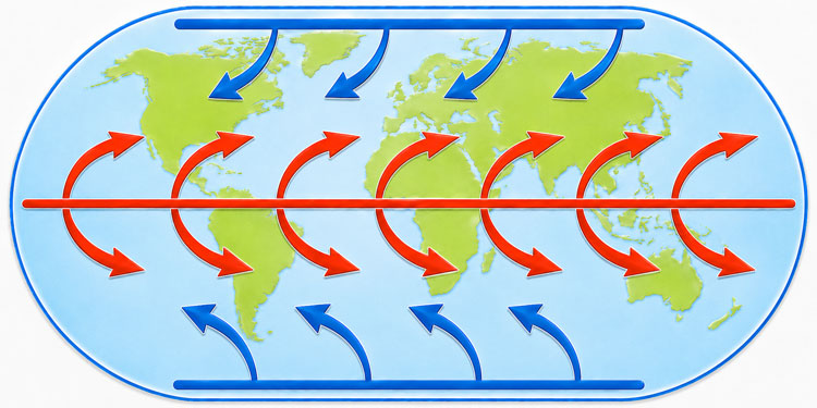
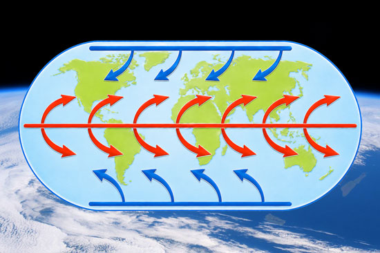
The illustration above shows you exactly how the moving air is affected once it starts deviating away from the tropics and polar regions, respectively.
Atmospheric elements (like moist air and clouds) at the tropics will always move at the same speed as the planet’s surface below. If it is pushed off course by any air movement and starts moving north or south, it starts drifting over an increasingly slower-moving surface.
As a result, the clouds or moist air will move faster than the surface below it as it continues to drift further away from the equator. (Indicated by the red arrows in the illustration above.)
A similar but opposite scenario occurs for atmospheric elements originating over the poles. Atmospheric elements (like moist air and clouds) at the polar regions will also always move at the same speed as the planet’s surface below. In this case, however, if it is pushed off course by any air movement and starts moving north or south, it starts drifting over an increasingly faster-moving surface.
As a result, the clouds or moist air will move slower than the surface below it as it continues to drift away from the poles towards the equator. (Indicated by the blue arrows in the illustration above.)
So the question remains. How does the Coriolis Effect cause and influence global weather systems around the world?
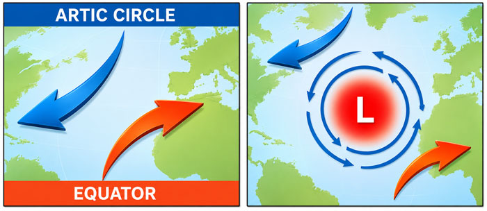
The illustrations above will give you a clear example of how just one type of weather system is formed as a result of the Coriolis Effect.
We now know that air moving away from the equator moves faster than the Earth’s surface beneath it. At the same time, air moving away from the poles moves slower than the Earth’s surface beneath it.
Now let’s introduce a low-pressure system to the scenario. The air from both the equator and polar regions will be pulled towards and start rotating around the low-pressure system (air always flows from an area of high pressure to an area of low pressure).
In the Northern Hemisphere, as illustrated above, this forms a counterclockwise rotation of winds around the low-pressure system. Over a warm ocean, hot moist air feeds the low-pressure system, which in turn strengthens the wind rotation around it.
And this is how a tropical depression can form, which may then develop into a tropical storm and eventually a hurricane if the weather system grows strong enough.
(You can read in detail how low-pressure systems and the surrounding winds develop hurricanes and typhoons in this article.)
Effects Of The Coriolis Effect
In explaining what the Coriolis Effect is, some of the biggest weather systems caused by this global phenomenon have already been highlighted. Hurricanes, tropical cyclones, and typhoons (all basically the same thing) have already been mentioned, as well as how the Coriolis Effect assists in their creation.
It also has a similar but opposite effect on high-pressure systems around the world. Winds rotate away from the center of a high-pressure system (as opposed to low-pressure systems). As a result, high-pressure weather systems rotate clockwise in the Northern Hemisphere and counterclockwise in the Southern Hemisphere.
Another very important result of the Coriolis Effect is the creation of Trade Winds. As air is warmed in the Tropics and starts moving away from the equator, it is deflected as a result of the Coriolis Effect.
As the air cools down, it descends back to Earth (at about 30 degrees north latitude). As the air descends, it moves back towards the equator from the Northeast to the Southwest. These persistent winds moving towards the equator are called Trade Winds.
A more indirect impact of the Coriolis Effect is its effect on the world’s ocean currents. Ocean currents are largely driven by global winds. As many of the Earth’s largest currents circulate in large systems called gyres, the impact of the Coriolis Effect is very evident here too.
Conclusion
I honestly don’t blame you if your head is spinning from reading through all the terms like “rotation, right, left, clockwise, counterclockwise, and deviating” spread throughout this entire article.
If everything is a bit unclear, just read through the article a couple of times and use the accompanying illustrations to better understand exactly how the Coriolis Effect works. It gets easier to understand. Just give it time.
I hope this article managed to shed some light on this sometimes “mysterious” but very important part of our global weather and climate, called the Coriolis Effect.
Until next time, keep your eye on the weather!