Defining Gale-Force Winds And How They Are Formed
Defining Gale-Force Winds And How They Are Formed

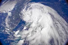
In certain regions of the world, a strong, persistent wind can appear seemingly out of nowhere. It can make simply staying on your feet a battle. This meteorological event is known as a gale-force wind.
Strong, gusty winds are not uncommon and can be found in storm systems like hurricanes, thunderstorms, and tornadoes. Gale-force winds, though, are not limited to just major storm systems.
The strong, persistent winds we are discussing in this article are the gale-force winds with gusts strong enough to cause significant structural damage and literally blow you off your feet.
These winds can occur without any strong weather system seemingly present and can last a whole day. We need to investigate and find out what exactly these gale-force winds are to understand what is causing them in the first place.
Defining A Gale
The introduction already hinted at what a gale-force wind is. However, one needs to establish a more detailed definition of what this phenomenon is before examining its development and characteristics in more detail.
What Is A Gale-Force Wind?
 A gale-force wind or gale is a strong, persistent wind ranging from 62 km/h (38 mph) to 88 km/h (55 mph) and is typically associated with but not limited to coastal regions.
According to the Beaufort Scale, gale-force winds are broken down into four subcategories.
Typically, these strong winds are caused by a steep pressure gradient, defined by the amount of pressure change over distance. It has to be noted that the US National Weather Service classifies a gale as a wind with speeds of 63 – 87 km/h (39 – 54 mph), so the classification of this type of wind may vary from one region to another.
The word “gale” is actually an appropriate word choice if you look at its origins. The word gale stems from the Old Norse word “galinn,” which literally means “frantic,” “mad,” or “tiresome.”
Naturally, winds of these wind speeds can be very dangerous and destructive. As a result, whenever a gale is predicted, it is normal for weather forecasters to issue gale warnings.
The Beaufort Scale
Even though different countries and regions have different definitions of what a gale force wind is, using the Beaufort Scale has some clear advantages:

Diagram displaying part of the Beaufort Scale that contains the 4 categories of gale-force winds (highlighted in red).
It not only breaks down the different gale strengths into 4 separate categories, but each one is clearly defined with its own description and associated land & sea conditions highlighted.
It also shows where gale-force winds sit in comparison with other wind strengths, which helps you to view any type of wind in context. It is helpful to assess the threat a gale poses and accurately convey relevant information to a third party familiar with this classification.
(The Beaufort Scale was created by Rear-Admiral Sir Francis Beaufort, a hydrologist in the Royal Navy, in the 1830’s. This scale was widely adopted throughout the Navy and even adapted for non-naval applications in the 1850s.)
As is the case with most other weather phenomena, things are not as simple as the definition above may suggest. There are actually a number of different factors and weather systems that can form gale-force winds in a variety of ways.
What Are The Causes Of Gale-Force Winds?
Wind is the result of air flowing from an area of high pressure to low pressure. This is why there are normally winds of varying strength present around a low-pressure system.
(You can find out more about the formation of wind, as well as its relationship with high and low-pressure systems, in this in-depth article.)
Tropical storms, cyclones, and hurricanes illustrate this point very clearly. Depending on the low-pressure system’s strength, winds of gale-force strength are reached very quickly and can quickly build up to reach hurricane strength wind speeds.
Gale-force winds are not just formed as a result of storm systems, though. Sometimes, on a seemingly otherwise clear and pleasant day, you can suddenly be hit by winds quickly building up to gale-force speeds.
Anyone living at the coast, specifically in areas where the coastline’s relief plays a part, may be very familiar with these winds. Simply put, a gale force wind in these areas can sometimes be seen as a “sea breeze on steroids”…
During the summer months, both the surface of the ocean and land are heated up by the sun. The land heats up much more quickly than the ocean. During the afternoon, the land also cools down much more quickly than the ocean.
A low-pressure system over land is created as a result. The warm air over the ocean flows towards the low-pressure system over land, and it is this air movement that is commonly referred to as a sea breeze.
This sea breeze can sometimes turn into a gale-force wind in specific areas and under certain conditions. For example, Cape Town, South Africa, is notorious for its strong gale-force winds often experienced during the summer months.
These gale-force winds in coastal regions are formed as a result of mainly 2 factors:
1. Occasionally, the difference between the low-pressure and high-pressure air over land and sea is so big that the breeze can quickly turn into a strong wind.
2. The region’s mountainous relief (like Cape Town) is responsible for amplifying the strength of these winds through a funnel effect. (The wind is being channeled through a narrow area, substantially strengthening it and increasing wind speeds.)
This results in gale-force winds in certain areas of the Cape Peninsula. It is not that uncommon for winds to reach speeds of 120 km/h (75 mph).

Cape Town is just one example of this phenomenon that takes place in coastal regions all over the world. San Francisco is also famous for its strong gale-force winds during the summer months.
Here also, a combination of terrain and the large contrast in ocean & land temperatures is responsible for these strong winds. Especially in the San Francisco Bay Area, wind funnels through at the Golden Gate, reaching gale-force speeds with gusts of up to 64 km/h (40 mph).
How To Recognize Gale-Force Winds And What To Expec
Gale-force winds are relatively easy to spot once they start to develop. They can be recognized by their persistent nature, which typically lasts for extended periods, unlike short-lived gusts normally associated with passing weather.
You can feel a gale as the pressure of the wind pushes against your body, making it hard to stay upright and often forcing you to lean into the wind. You will also see objects like tree tops and traffic signs bent due to the sheer force. Objects that stay in place during normal windy conditions are flung around at high speeds, turning them into potentially dangerous projectiles.
You can also hear the familiar sound a gale makes as it howls through narrow spaces like city streets, and the rushing/roaring noise it makes as it blows through treetops.
The hissing sound sand makes as it is lifted into the air and blown at high speeds, as well as the roar of the waves as it is “roughed up” in coastal regions, are very characteristic of this phenomenon. Anyone who experienced this personally will testify to this, especially the painful experience of getting “sandblasted” by the fast-moving grains of sand.
Care should be taken when driving in these conditions, especially in vehicles with high wind resistance, like trucks and vans, as the wind strength is more than capable of toppling a vehicle.
Gale-force winds are also often an indicator of approaching weather systems, like a front or low-pressure system nearby, which is another consideration to keep in mind.
Conclusion
As you can conclude from this article, gale-force winds (or simply gales) are not specifically associated with any particular weather system.
Rather, winds are classified as gale-force winds mainly because of the speed at which they are traveling, and not where they take place or how they are formed.
Therefore, as already stated, winds measuring between 7 and 9 on the Beaufort Scale, indicating wind speeds of between 62–88 km/h (38–55 mph), are all considered to be gale-force winds.
We also touched on how these winds are generated and on the origins of the term to better understand its use.
Until next time, keep your eye on the weather!