El Niño And La Niña – What They Are, Their Differences, And How They Impact Global Weather And Climate Patterns
El Niño And La Niña – What They Are, Their Differences, And How They Impact Global Weather And Climate Patterns

Two types of weather phenomena, known as El Niño and La Niña, are gaining increased attention due to their significant impact on global weather events. We examine what they are and how they differ.
El Niño is a series of atypical weather patterns caused by unusually warm ocean water in the Pacific shifting eastward and accumulating along the west coast of South America. La Niña forms when stronger trade winds push warm water toward Southeast Asia, resulting in an upwelling of cold water near the west coast of South America.
In recent years, the term “El Niño” started surfacing in weather forecasts and the news as a result of its widespread impact on global weather, specifically the resulting droughts in some parts of the world. Inevitably, its counterpart, “La Niña,” also started getting attention.
So what is the difference between these two “interestingly” named phenomena, and how do they affect the weather to such an extent that we as humans get impacted as a result?
To answer this question, we have to take a look at what specifically each one is, how it is formed, and the effect it has on the weather.
What Is El Niño?
Before we look at how the El Niño phenomenon forms and what its effect on weather and climate is, we need to first understand what exactly it is:
El Niño Definition

El Niño can be summarized as a series of unusual weather patterns and events caused by warm Pacific Ocean waters shifting away from their normal flow.
Instead of accumulating near the Southeast Asian coast, as is usually expected, the warm waters flow eastwards around the equator and accumulate near the northwestern coastline of South America. This has a profound effect on the weather.
With a clear understanding of what the El Niño phenomenon is, we can take a closer look at how it is formed.
What Causes El Niño?
We already established that the El Niño phenomenon is a direct result of warm water being pushed in an easterly direction to accumulate against the northwestern coastline of South America.
What causes these waters to change direction in the first place is a weakening or change in the direction of trade winds. Approximately every 3 to 5 years, the strength of the trade winds is substantially diminished or even reversed.
Under normal conditions, the waters along Southeast Asia will be warmer than the much colder waters pushing up along the west coast of South and Central America.
During El Niño years, however, the warm water is now pushed in an easterly direction, canceling the effect that the warm waters off the east coast of Southeast Asia and the cold waters off the west coast of South America would have had under normal conditions.
The typical, contrasting warm and cold temperatures between the coastlines of the two continents are greatly diminished. With the heat largely evened out between the two continents, the warmest waters are now situated near the center of the Pacific Ocean.
As ocean temperatures are one of the main drivers of weather, the El Niño phenomenon leads to drastic weather changes on a global scale, as you are about to learn.
(Warm ocean water is responsible for some of the most extreme weather events on the planet. You can find out more about how warm water triggers these events in this article.)
The Effects Of El Niño On The Weather
If you regularly read other articles about the weather, you will know that the weather is a very complex system, influenced by countless variables that result in weather patterns and conditions on a local and global scale.
The El Niño effect is no different. It has an immediate impact on the global climate, but also longer-term global effects on weather patterns.
The warm and moist waters along the South and Central American West Coast create a much wetter climate in the region. Countries like Paraguay, Brazil, and Argentina experience more extended periods of intense precipitation.
Southeastern parts of the United States and Mexico also experience higher volumes and longer periods of rainfall due to the same warm and humid ocean waters. An increase in extreme weather events is also triggered by the warm waters in the East Pacific.
As mentioned, El Niño also has a long-term effect on global weather patterns. The change in water temperature affects the major wind currents in the upper atmosphere. It is these major wind currents that have a profound effect on the weather systems worldwide.
Some regions experience wetter short-term climate conditions, with extended periods of precipitation and more extreme weather events. Many areas around the world, however, are experiencing much drier weather conditions, as rain-bearing weather systems are now being moved away from these regions.
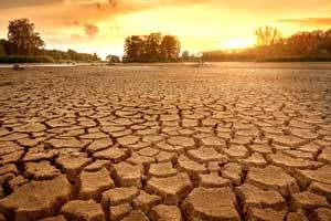
Regions like Southern Africa, Australia, Indonesia, and India are subjected to prolonged periods of dry conditions during this period. This has led to droughts being declared in some of these countries.
Although the El Niño cycle occurs typically every three to five years, it appears at irregular intervals, making it hard to forecast. It can last anything from nine months to two years. (To be classified as an El Niño effect, the warming has to last for a minimum of nine months.)
The reason why this is important is that the dry spells and droughts in the affected countries are amplified by the impact of Global Warming.
The compounding effect of both El Niño and Global Warming is causing an increased intensity and prolonged duration of the dry weather. This is having severe economic and humanitarian consequences for many of these countries.
What Is La Niña?
Just like El Niño, before we look at how the La Niña phenomenon is formed and what its effect on weather and climate is, we need to first understand what exactly it is:
La Niña Definition

La Niña can be summarized as the weather and climate patterns that are formed as a result of warm water being shifted further away from the west coast of South America in the direction of the Southeast Asian coast.
This causes colder than usual water to rise up near the west coast of South America. As a result, the Central and Eastern Pacific Ocean is a few degrees colder than usual.
With a clear understanding of what the La Niña phenomenon is as well, we can take a closer look at how it is formed.
What Causes La Niña?
During average years, warm water accumulates near the Southeast Asian coast, while colder water is brought to the surface in the Central and Eastern Pacific Ocean through a process called upwelling.
(Upwelling is the process through which colder water is brought to the surface as a result of surface winds and ocean currents.)
During La Niña years, though, abnormally strong trade winds have a significant impact on the westerly movement of warm ocean water. The stronger winds force large portions of warm water to shift and end up near the Southeast Asian coast.
As warm water is removed from the west coast of South America, more cold water is forced to the surface. As a result, the temperature of the Central and Eastern Pacific Ocean waters is substantially lower than usual.
La Niña usually occurs every three to five years, although it can be very inconsistent and last for extended periods.
A period of La Niña can be officially declared if a sustained drop in ocean temperatures below the norm is observed for at least five months in the Central and Eastern Pacific Ocean.
As I previously mentioned, ocean temperatures are one of the main drivers of weather, which means the La Niña phenomenon also leads to drastic weather changes on a global scale, just like the El Niño effect.
The Effects Of La Niña On The Weather
There is a reason why La Niña is called the counterpart of El Niño. The weather conditions created by the phenomenon are almost the direct opposite of those created by El Niño.
Due to the much colder water near the South American coast, the lack of moisture in the air is restricting cloud formation in the area, which leads to dry weather conditions in western South America and the southern parts of the United States during La Niña years.
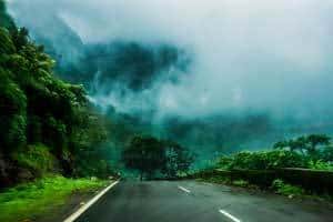
On the western side of the Pacific Ocean, the warm water is resulting in a larger volume of moist air, which leads to more rainfall than usual in Southeast Asia (especially Indonesia, the Philippines, and Malaysia). Rainfall normally associated with the monsoon season in India and Bangladesh is also higher than usual.
The impact of La Niña is felt on a global scale as well. Australia is one of the countries that can experience periods of high rainfall during the duration of the phenomenon. La Niña has even been associated with flooding in this area.
Other areas that experience higher levels of rainfall during this period include Southern Africa and the Northwestern United States.
Increased cyclonic activity in the Asian region has also been linked to La Niña.
How To Tell Whether An El Niño Or La Niña Event Is Occurring
Unlike localized weather events like storms or tornadoes, El Niño and La Niña are large-scale climate patterns that cannot directly be observed, since they are identified through sustained changes in ocean temperatures in the Pacific Ocean and are officially declared by climate monitoring organizations.
One of the primary indicators is a change in sea surface temperatures in the central and eastern Pacific Ocean. During El Niño, these waters are warmer than usual, while La Niña is characterized by cooler-than-average ocean temperatures in the same region.
Another important factor is the behaviour of the trade winds. During El Niño cycles, the trade winds weaken or may even reverse direction. During La Niña cycles, these winds become stronger than normal.
For most people, however, the most noticeable signs come from changes in regional weather patterns. El Niño is often associated with drier conditions in regions such as Southern Africa, Australia, and Indonesia, while wetter conditions occur along the west coast of South America and parts of the southern United States.
La Niña typically produces the opposite effect. Countries like Southern Africa, Australia, and parts of Southeast Asia often experience increased rainfall, as well as a higher risk of flooding, while regions along the west coast of South America and parts of the southern United States tend to become drier.
These large-scale shifts can also lead to changes in seasonal weather patterns, including longer dry spells, extended periods of rainfall, and an uptick in certain types of extreme weather events.
It is important to note that no single indicator confirms the presence of El Niño or La Niña. Instead, scientists rely on a combination of ocean temperature data, atmospheric conditions, and long-term weather patterns to determine whether one of these phenomena is occurring.
What Is The Difference Between El Niño And La Niña And Their Impact On The Weather?
By defining what precisely El Niño and La Niña are, how they are formed, and the impact each one has on local and global weather and climate, this question has already been mostly answered.
However, it will be useful to list some of the key differences between the two phenomena:
-
- El Niño is a Spanish term meaning “little boy,” while La Niña is also a Spanish term meaning “little girl.”
- El Niño is associated with warmer water in the Pacific Ocean along the equator, while La Niña is associated with colder-than-usual water temperatures in the Central and Eastern Pacific Ocean.
- El Niño is associated with weakened atmospheric pressure differences across the Pacific, while La Niña is associated with stronger-than-normal pressure differences.
- Trade winds die down or change direction during El Niño cycles, while they strengthen during La Niña cycles.
- In the Pacific Ocean, warm water suppresses the upwelling of deeper waters during El Niño cycles, while cold water stimulates the upwelling of deeper waters during La Niña cycles.
- Heavy rains over the west coast of South America are associated with El Niño cycles, while dry conditions are experienced over the region during La Niña cycles.
- Areas in Southern Africa and Australia experience very dry conditions during an El Niño cycle, while more humid conditions are experienced during a La Niña cycle.
These are just a handful of differences between El Niño and La Niña phenomena, but they summarize the key differences between the two.
Throughout this article, I brought up the subject of global warming on quite a few occasions. If you want to find out more about what it is and how it is formed, you can read more about it in this article.
Conclusion
You now have a very good idea of what El Niño and La Niña are, but more importantly, the effect they have on weather and short-term climate patterns, both locally and globally.
We haven’t even touched the surface of how many variables are really involved in both processes, the effect global warming has on everything, and the real impact of both processes throughout every part of the planet.
For the purpose of this article, though, you should have a thorough and concise insight into the workings and impact of both processes.
Until next time, keep your eye on the weather!