A rare event, characterized by an unexpected gust of warm, dry wind originating seemingly out of nowhere, occurs under certain conditions during a warm summer night. It is better known as a heat burst.
A heat burst is defined as a rare meteorological phenomenon characterized by strong gusts of dry winds accompanied by a sudden and significant rise in temperature. This phenomenon typically occurs during the evening on warm days in the wake of a dissipating thunderstorm during the hot summer months.
It is not uncommon for some of the most extreme and violent weather events one will ever experience to stem from larger storm systems, specifically those involving thunderstorms.
The subject of this post is yet another example of the “byproduct” of a thunderstorm. Unlike most other weather events involving these storms, though, it is not characterized by cold or wet weather. A heat burst is a rare occurrence with unique characteristics.
This article examines what a heat burst is, how it gets formed, and also takes a look at it its specific features.
Heat Burst Definition
The introduction already gave away some hints of the makeup of this weather event and its formation. What precisely it is and how it develops will shortly be discussed in detail.
Before delving in, though, it is imperative to provide a more formal and concise definition of a heat burst to provide a solid foundation to work from:
What Is A Heat Burst?

A heat burst is a sporadic meteorological event that is defined by strong gusts of dry winds accompanied by a sudden and significant rise in temperature. This phenomenon usually occurs during the summer months, typically on warm days during the evening in the wake of a dissipating thunderstorm.
In simple terms, a heat burst is a warm and dry gust of wind that occurs on a hot day during the summer months and usually takes place in the evening. It follows in the wake of a dissipating thunderstorm and causes a significant rise in the surrounding air temperature.
Its formation is similar to that of a microburst, but as you will soon learn, a few subtle differences create a very different outcome.
How A Heat Burst Develops
When a storm cloud starts to dissipate, lift, and clear up, it leaves a layer of cold air behind. At this stage, most moisture has been removed from the air during rain showers or other forms of precipitation.
Due to gravity and disappearing updrafts, the dense air starts to sink to the ground. As it accelerates down, it gets subjected to increasing air pressure and friction.
The increased atmospheric pressure causes the air to warm adiabatically (similar to Chinook or Föhn winds down the slopes of a mountain). The friction between falling and stationary particles creates additional heat that contributes to the thermal buildup of the falling air.

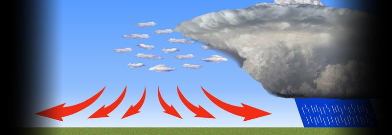
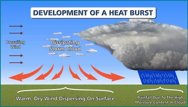
The red arrows indicate the dispersing warm & dry winds of a heat burst below remnants of a dissipating storm cloud. Click on the image for a larger view.
The heated air also forces the remaining moisture to evaporate, while momentum allows the layer of air to continue to speed to the ground. The result is a heated, dry pocket of air that hits the surface, forcing warm gusty wind to disperse away from this point of impact.
To those readers familiar with a microburst, this process may sound similar to the formation of a microburst. There are some similarities but also a few different characteristics that allow for the creation of a very different phenomenon.
These are among some of the defining characteristics of a heat burst that will be discussed in the next section.
Characteristics Of A Heat Burst
For a heat burst to take place, a few conditions need to be in place. Some of them are not only characteristic of the phenomenon but also are what differentiate them from other weather events like microbursts. We look at them first.
1) High Elevation
A heat burst typically originates high in an anvil cloud (that is so synonymous with thunderstorms). It is due to the fact that the phenomenon occurs in the wake of dying thunderstorms, when clouds start to lift and dissipate, leaving a layer of cold air behind.

It is at this high altitude at where a heat burst forms, which allows it to travel further when it sinks to the ground. The greater distance enables it to be subjected to increased pressure and friction for an extended period, causing more heat to build up in the layer of falling air.
The lower altitude (combined with a higher moisture content) at which a microburst occurs is part of the reason that the air reaching the ground remains cold and sometimes mixed with different types of precipitation.
2) Little Or No Moisture
Another characteristic that is unique to a heat burst compared to similar events is the extremely dry air associated with this phenomenon.
By the time a heat burst starts forming, the storm system already dissipated, and most of the moisture lost due to heavy rainfall that occurred during the peak of the thunderstorm.
The little moisture that is left in the pocket of air evaporates in the warm air as it plummets to the ground. It is not uncommon to observe the phenomenon called virga (visible rain that evaporates before reaching the ground) beneath the cloud base, where a heat burst occurs.
The opposite is true for a microburst. The high moisture content within a thundercloud allows this phenomenon to stay cold or even be cooled further as it descends to the surface.
3) Strong Winds
One of the two main characteristics of a heat burst is the strong gusts of wind that it produces as the pocket of warm air hits the ground and gets dispersed in multiple directions over the surface.
The height from which the layer of air falls allows it to accelerate and reach high velocities before hitting the ground. Wind gusts can easily exceed 121 km/h (75 mph). For example, in May 1996, Oklahoma experienced a heat burst with wind gusts of up to 153 km/h (95 mph).
4) Sharp And Significant Temperature Rise

The second and most defining main characteristic of a heat burst is the sudden and significant rise in temperature at the surface. This sudden rise in temperature can last anything from a few minutes to a couple of hours.
In most cases, the rise in temperature occurs in a short amount of time. The temperature increase is also significant. It is capable of increasing the current atmospheric warm air by as much as 10° Celsius (50° Fahrenheit) or more.
Extreme examples include Almeria, which occurred in Spain in July 2019. Temperatures jumped from 28° Celsius (82° Fahrenheit) to an incredible 41° Celsius (106° Fahrenheit) in just 30 minutes.
In July 2016, Oklahoma also experienced a similar heat burst when the temperature rose from 27° Celsius (80° Fahrenheit) to 41° Celsius (106° Fahrenheit).
Conclusion
What became clear throughout this post is that a heat burst may not be such a well-known weather event, but one that will definitely be noticed if ever experienced. It has a dramatic effect over a short period, as the few examples in the last section illustrated.
It should not be confused with a heatwave, though, which can last for days or months and also have a significant impact on weather and climate of any region it impacts.
This post aimed to illustrate what a heat burst is and how it develops, as well as highlight the characteristics that define it. If the phenomenon were unknown or unclear to you, you would now be able to understand it, as well as the mechanisms that underlie it, entirely.
Never miss out again when another interesting and helpful article is released and stay updated, while also receiving helpful tips & information by simply clicking on this link .Until next time, keep your eye on the weather!

