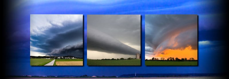
Certain cloud types appear to have very distinct shapes and sizes. Arcus clouds are one such example, but these cloud formations may also be an indication of something much more ominous approaching.
Arcus Cloud is the meteorological umbrella term used for low-lying accessory clouds that spread out horizontally, usually from the boundary of a more extensive storm system like a thunderstorm. These cloud formations have a visually striking appearance and typically form as shelf or roll clouds.
Under the right conditions, many cloud formations make for some of the most striking photographs you can take. Some clouds, though, are so visually impressive and awe-inspiring that a picture doesn’t do it justice. Arcus clouds are one such example.
This article focus on what arcus clouds are, how they form, as well as the different types of arcus clouds.
What Is An Arcus Cloud?
It is clear that arcus cloud formations are responsible for some of the most spectacular views one can observe from the planet’s surface. But there is more substance to this meteorological phenomenon than merely looks.
Arcus Cloud Definition
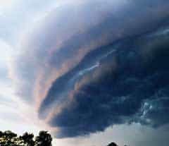
Arcus Cloud is the umbrella term used in meteorology for low-lying accessory clouds that spread out horizontally, usually from the boundary of a more extensive storm system like a thunderstorm. These cloud formations have a visually striking appearance and typically form as shelf or roll clouds.
The summary provides a concise but cryptic definition of what an arcus cloud is and how it forms. A broader definition is needed to fully understand this type of cloud formation.
Arcus clouds are low-altitude clouds with the cloud base forming at the height of approximately 2 kilometers (6500 feet).
Arcus clouds are divided into two main categories: Shelf Clouds and Roll Clouds. As a result, arcus clouds are either wedge-shaped or in the shape of a horizontal tube-shaped column (depending on whether a shelf or roll cloud develops).
The two major types of clouds associated with the formation of arcus clouds are Cumulus and Cumulonimbus. Notably, the severe updrafts and downdrafts present in cumulonimbus clouds are responsible for the creation of many spectacular arcus formations.
Unlike the cumulonimbus clouds that form the basis for the formation of many arcus clouds, arcus clouds themselves develop and spread out in a horizontal fashion.
Arcus clouds pose no direct danger in the form of precipitation or strong winds, but in many cases, act as a precursor for approaching thunderstorms and severe weather.
How Do Arcus Clouds Form?
Although the two types of arcus clouds, shelf and roll clouds, have unique characteristics and a specific way in which each one develops, they both have a similar origin.
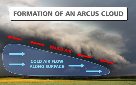
Cold air flow out from the storm front and spreads horizontally, forcing the warmer air at the surface into the air. The arcus cloud forms along this border of rising warm air and advancing cold air.
The principle way in which arcus clouds form can be summarized in the following steps:
- 1Thunderstorms are characterized by strong updrafts and downdrafts in the stormcloud. It is the strong downdrafts present at the leading edge of a thundercloud that is primarily responsible for the creation of arcus clouds.
- 2Cold air, cooled down by altitude and precipitation, is carried to the ground by downdrafts from where it spreads out horizontally in front of the storm system.
- 3The heavier cool air spreads out quickly over the ground and pushes underneath the warmer moist air, lifting it into the atmosphere.
- 4As the warm air rises and cools down, condensation takes place, which leads to the formation of arcus clouds with their unique shape & characteristics.
- 5Depending on the specific atmospheric conditions and location, this process leads to the formation of the familiar wedge-shaped shelf clouds or the round cylindrical-shaped roll clouds.
Both shelf clouds and roll clouds each have a unique appearance with characteristics of their own, which we will address in the following section.
Types Of Arcus Clouds
As stated in the summary, arcus clouds can be divided into two primary types of formations:
- Shelf Clouds
- Roll Clouds.
These two types of arcus clouds may have a similar origin, but appear substantially different with different characteristics which can be best understood by looking at each cloud formation individually.
Shelf Cloud: The Best-Known Arcus Cloud Formation
The most common type of arcus cloud is the ominous-looking shelf cloud that usually precedes large thunderstorms. When discussing arcus clouds, this is the type of cloud formation that generally springs to mind.
What Is A Shelf Cloud?
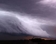
A shelf cloud is a type of arcus cloud that is characterized by its visually striking wedge shape and horizontal development. It typically develops at low altitudes from the leading edge of its parent cloud, known as a cumulus congestus cloud.
Shelf clouds usually develop out of the parent cloud called a cumulus congestus cloud. Congestus clouds are cumulus clouds that are taller than they are wide, in other words, with strong vertical development. They are also often a precursor to cumulonimbus clouds.
The familiar ragged-looking underside of a shelf cloud is a result of turbulent winds, as well as wind shear caused between the updrafts and downdrafts.
Arcus clouds in the shape of shelf clouds are synonymous with a derecho, a widespread and potentially devastating storm system you can read all about in this article.
Shelf clouds appear at the leading edge of this dangerous storm front, and although they pose no danger themselves, their appearance point to the looming threat of the derecho that follows close in its footsteps.
As a shelf cloud passes overhead, it is usually followed by a dark tumultuous section of sky commonly known as the whale’s mouth in meteorological circles. This stretch of weather slots in between the appearance of shelf clouds and the arrival of the thunderstorm.
(The dark, turbulent stretch between the edge of a shelf cloud and a thunderstorm is sometimes characterized by a distinct wavy appearance, known as asperitas clouds. These clouds don’t appear that often but are almost as spectacular as the shelf cloud itself.)
Shelf Cloud Formation
The formation of a shelf cloud is identical to the process described earlier in this post. From the fifth point, though, the process is unique to the development of shelf clouds:
As the cold air from the outflow boundary (leading edge of the storm) moves forward, it tilts the rising warm air along its boundary.
It is along this boundary between the warm updrafts and cold downdrafts that shelf clouds form. As the warm air keeps rising along this border, it cools down, and condensation takes place, which results in the formation of a shelf cloud.
Roll Cloud: Shelf Clouds’ Less Famous Cousin
A lesser-known type of arcus formation is called a rolling cloud. It is the second of the two types of arcus clouds.
Although a roll cloud is classified as an arcus cloud, it differs significantly from its more famous cousin, the shelf cloud. One needs to take a closer look to understand its unique characteristics, but one first needs to define it more clearly:
What Is A Roll Cloud?
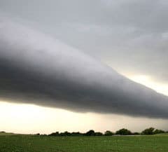
A roll cloud is a rare type of arcus cloud characterized by its round tube-shaped formation, which forms at very low altitudes and appears to rotate on its horizontal axis. It acts as a single wave known as a soliton and, unlike a shelf cloud, develops completely independent from other clouds.
As already stated, the appearance of roll clouds is a rare occurrence. It is no less spectacular than well-documented cloud systems but is a relatively rare occurrence. The biggest reason for their scarcity is that the weather conditions have to be close to perfect for them to occur.
In the WMO’s Cloud Atlas, it is now officially called volutus clouds. Although it is still viewed as a type of arcus cloud, the World Meteorological Organization (WMO) recently classified it as an entirely separate cloud species.
What makes a roll cloud unique is that it appears as a solitary independent cloud, completely detached from any parent cloud. On very rare occasions, one can view several roll clouds appearing in succession.
Roll clouds also act like a soliton when it comes to their motion. A soliton is a single wave with a single crest that moves ahead without changing its speed or size. (Which sums up the movement of a roll cloud.)
It is evident that roll clouds have some characteristics that clearly distinguish it from shelf clouds, even though it still falls within the same family of clouds.
Difference Between A Shelf Cloud And Roll Cloud
The biggest difference between a shelf cloud and a roll cloud is the fact that a shelf cloud forms part of the larger storm cloud from which leading-edge it develops, while a roll cloud is an entirely independent cloud, detached from any cloud formation.
The well-known Morning Glory Cloud formation is arguably the best example of a roll cloud formation. It is the only type of roll cloud that can be predicted with any amount of certainty, and occur mainly in Northern Australia and The Gulf OF Carpentaria.
Roll Cloud Formation
Although the formation of a roll cloud generally forms in the same way as the process described earlier in this post, it also differs in a significant way:
A roll cloud forms completely independent from any bigger cloud system. In many cases, it occurs without any other significant cloud development even in sight.
Although not physically attached to a parent cloud, a roll cloud still forms at the leading edge or gust front of a storm system.
In some instances, the downdrafts that accompany a storm system form some distance in front of the stormcloud’s edge. As a result, a roll cloud can form at the border between updrafts and downdrafts without the presence of the larger storm cloud formation.
Sometimes, though, a thunderstorm will clear up and dissipate completely, leaving only the updrafts and downdrafts behind. In turn, they can lead to the formation of roll clouds in otherwise clear and fair weather.
Conclusion
It is clear that all arcus clouds follow a similar pattern when it comes to their development and the factors involved in the process. The physical manifestations of the two types of arcus clouds, however, are dramatically different.
Shelf clouds develop their familiar ragged wedge-shaped form, while roll clouds are characterized by their round, tube-shaped formation. Shelf clouds further develop at the leading edge of a storm cloud, while roll clouds form independently from any other cloud.
In conclusion, this article focused on explaining what an arcus cloud is, how it develops, and highlighting the different types of arcus clouds.
Never miss out again when another interesting and helpful article is released and stay updated, while also receiving helpful tips & information by simply following this link .Until next time, keep your eye on the weather!

