When the conditions are just right, a rare event characterized by a sudden downpour of rain with extreme wind gusts occurs during the development of a severe storm. This is better known as a microburst.
A microburst is defined as a powerful localized downdraft created by a column of fast-sinking air through the base of a storm cloud, which spreads out horizontally upon hitting the surface. This meteorological event is divided into dry and wet microbursts, which can both result in severe damage.
A microburst usually occurs during a thunderstorm or heavy rain shower and often is relatively short-lived. It also dissipates as quickly as it arrived.
Wind speeds can reach up to 160 km/h (100 mph) as the air hits the ground and disperse. As a result, this phenomenon often gets confused for a tornado or hurricane.
This article examines what exactly a microburst is, how it develops, and also looks at the different types of microbursts.
What Is A Microburst?
Meteorologist Ted Fujita was responsible for labeling the term microburst. He defined it as a downburst that occurs over a small area that affects a region with a diameter of no more than 4 kilometers (2.5 miles) in size.
(He was also responsible for the term, macroburst, to identify downbursts larger than 4 kilometers (2.5 miles).)
Although a microburst displays many of the characteristics of a tornado(and sometimes a hurricane), it is a completely different type of meteorological event. Before examining how it develops in more detail, one needs to define what precisely a microburst is:
Microburst Definition
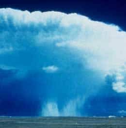
A microburst is a powerful localized downdraft created by a column of sinking air through the base of a storm or rain cloud. This meteorological phenomenon can be divided into dry and wet microbursts, both of which can cause severe damage to the surface below and surrounding objects in their path.
A cumulonimbus cloud, in which a thunderstorm usually occurs, can reach heights of up to 16 000 meters (52 000 feet). It is at these high altitudes where the cold air develops that forms the basis for a microburst.
One more characteristic that makes it so difficult for meteorologists to forecast is the speed at which a microburst develops and also dissipates. This is also what makes it so unpredictable and dangerous.
How A Microburst Develops
With a clear understanding of what a microburst is, it is important to know how it develops. It will not only help to create a clear understanding of how and why it occurs but also why it displays the characteristics that are so unique to this phenomenon.
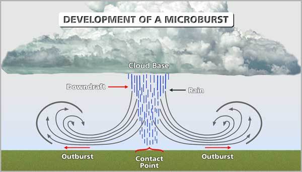
Development and execution of a typical microburst. Click on the image for a larger view.
A microburst initially starts to form in the top part of a storm cloud, where pockets of cold and moist air accumulate and continue to build up. Two main factors trigger and contribute to a column of cold air to start dropping and accelerate to the ground:
- Precipitation Loading
- Evaporation Cooling
Sometimes, precipitation loading on its own can initiate a microburst, but it usually is a combination of both, working together to create a downburst with potentially devastating effects. A closer examination of each will show how they contribute to the occurrence.
1) Precipitation Loading
Precipitation loading is the raindrops, hail, ice crystal, graupel, and other forms of water that accumulate in the upper regions of a storm cloud. It gets carried up and kept airborne by the strong updrafts that occur within a large storm system.
Water carries a lot of weight, and when updrafts are no longer able to keep it in the air, it starts to drop to the ground. Sometimes it is the sheer weight of the moisture, combined with a dissipating storm system and weakening updrafts that trigger the event.
2) Evaporation Cooling
In the upper troposphere, external cold, dry air also comes in contact with the moist air in the cloud. It causes the moisture to start evaporating. Since evaporation is a cooling process, the air in the cloud begins to cool down.
The resulting pocket of cold air is much denser and heavier than the surrounding warmer air. As a result, this column of cold heavy air will start to sink to the ground.
When the sinking air exists the cloud base, it comes in contact with more dry air. Here, evaporation continues to take place, which cools the air down even further. As a result, the cold air drops even faster and accelerates towards the ground.
The actual occurrence of a microburst can be broken down into three primary stages:
- Contact Stage
- Outburst Stage
- Cushion Stage
By looking at each of these three stages individually, it will be easier to understand the complete process through which a microburst develops:
1) Contact Stage
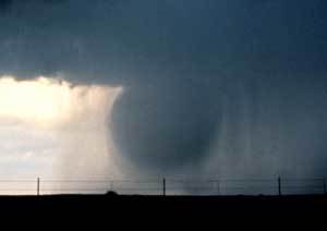
Microburst existing the cloud base before making contact with the ground.
During the initial stage of a microburst, cold air (often accompanied by raindrops) exists the cloud base and continues to accelerate to the ground.
The downdraft rushes towards and hits the ground at what is called the contact point (also called the splashdown point), from where strong winds diverge outwards.
(For clarity, you can use the image of a water-filled balloon, dropped from a height and bursting open when it hits the ground, with water being dispersed in all directions. The contact stage of a microburst closely resembles this image.)
2) Outburst Stage
The name of this stage itself is quite self-explanatory. During this stage, powerful winds get dispersed away from the splashdown point after contact with the ground.
These winds travel along the surface and can reach speeds of up to 160 km/h (100 mph) or more, powerful enough to cause severe damage to the environment and structures. Winds of this speed can flatten large trees and seriously damage large structures.
Depending on the type of microburst, the winds can be accompanied by heavy rain, which can add to the damage caused and pose additional dangers as well.
3) Cushioning Stage
In the final stages of the event, a layer of cold air forms at the surface where the downdraft first made contact with the ground. This cold air accumulated from the start of the microburst and built up as it progressed.
While the air, already at the surface and outer limits of the affected area, continues to blow strongly, the “cushion” provided by the layer of cold air below the downdraft prohibits any more air from reaching the ground.
This final stage marks the start of the end of a microburst, which will blow itself out shortly after no more wind from the downdraft can reach the ground. The duration of a microburst can last anything from a few seconds to a couple of minutes.
Types Of Microbursts
As I briefly touched on in the summary of what a microburst is, there are mainly two forms of this event:
1) Dry Microburst
A dry microburst occurs when no rain is present in the column of air reaching the ground. It happens when there is very little moisture present in the cloud, and the cloud base is situated at a relatively high altitude.
The little rain that emerges from the cloud base with the downdraft quickly evaporates in the dry air below the cloud before it can reach the ground (also known as virga). As a result, it is only the dry air that reaches the round and gets dispersed in multiple directions.
2) Wet Microburst
A wet microburst occurs when a combination of heavy rain and wind reaches and gets dispersed over the ground. This happens where there is a high percentage of moisture present in a cloud.
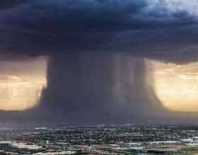
A wet microburst occurring over Phoenix.
When the combined weight of the different sources of moisture in the top part of the cloud becomes too heavy, it starts to sink. As it drops through the cloud, it drags the surrounding air down with it, which accelerates the speed of the sinking column of air.
Subsequently, a combination of rain and wind is caught in the column of air that crashes into the ground, and both get propelled outwards with potentially devastating results.
Conclusion
They may not be as well-known as tornadoes and hurricanes as extreme weather events, but microbursts are just as severe and destructive. It should be very clear to you after reading this post.
This article also illustrated that, even though many of the characteristics are the same as a tornado, a microburst is an entirely separate weather phenomenon that is formed and develops through very different mechanisms.
Never miss out again when another interesting and helpful article is released and stay updated, while also receiving helpful tips & information by simply clicking on this link .Until next time, keep your eye on the weather!
This article was originally published on ownyourweather.com. If it is now published on any other site, it was done without permission from the copyright owner.

