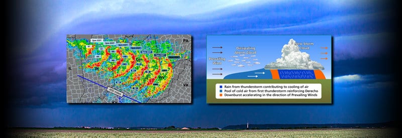
We are so focused on familiar storm systems like blizzards, tornadoes, and hurricanes that we tend to overlook larger and more dangerous meteorological events like derecho storms when they occur.
A derecho is defined as a powerful, large-scale weather event marked by a bow-shaped line of windstorms advanced by a series of heavy thunderstorms. It forms when winds maintain minimum speeds of 93 km/h or 58 mph, affected areas span at least 400 km or 250 miles, and last for a minimum of 6 hours.
Occasionally, though, the extreme weather you are experiencing may be part of something much bigger and more destructive. Since it exhibits the same characteristics as a weather event you are familiar with, it is easy to dismiss it as just that.
But what if the weather phenomenon you are experiencing has a bow-shaped line of winds at least 400 kilometers (250 miles) wide, accompanied by strong gusts that can reach 121 km/h (75 mph) or more. Also, this long-lived system can easily travel more than 600 miles.
The weather phenomenon that is the focus of this article is precisely one such storm. It is called a derecho. From the figures you saw in the previous paragraph, it should be clear that this is an enormous event with potentially widespread and devastating consequences.
This article examines what a derecho is, how it develops and also looks at the widespread effect of this meteorological phenomenon on humans and the environment.
What Is A Derecho?
From the introduction alone, it will become self-evident that a derecho is a very large weather event that affects a vast area. Before examining how this phenomenon develops, it is essential to have a clear definition of what precisely a derecho is:
Derecho Definition
A derecho is defined as a powerful, large-scale weather event marked by a bow-shaped line of windstorms advanced by a series of heavy thunderstorms. It forms when winds maintain minimum speeds of 93 km/h or 58 mph, affected areas span at least 400 km or 250 miles, and last for a minimum of 6 hours.
The name, Derecho, is derived from Spanish, which literally means “straight in English. It is highly appropriate since the winds that characterize this storm system travels in a long straight (with a slight bow-like curve).
To be classified as a derecho, winds must reach sustained speeds of at least 93 km/h (58 mph), the affected area is at least 400 kilometers (250 miles) wide, and the storm lasts for a minimum of six hours. Occasional wind gusts of at least 121 km/h (75 mph) must also occur.
These widespread and fast-moving winds extend over several hundred miles and last for an extended duration. They often result in the formation of tornadoes, hail, and flooding, which can cause widespread damage and destruction.
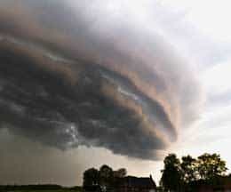
Visually, an approaching derecho is often characterized by a bank of heavy shelf clouds (also known as arcus clouds), which are synonymous with this extreme weather event. These clouds have a distinct shape that is as awe-inspiring as it is ominous.
How A Derecho Develops
One of the most critical components and main driving forces of a derecho is an extensive grouping of a series of thunderstorms traveling in the same direction.
However, there are specific factors, both inside and outside these thunderstorms, that trigger and cause a derecho to form and grow into the widespread and devastating weather event we know:
Downbursts
The strong winds that are so characteristic of a derecho are produced through multiple occurrences of a process called a downburst within thunderclouds.
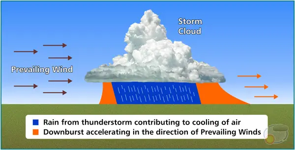
Early stages in the development of a derecho. Click on image for a larger view.
A downburst is a column of cold air that develops in the upper regions of a thundercloud. It starts to sink and accelerate to the ground. When the air hits the ground, strong winds get dispersed in multiple directions.
(Downbursts can further be divided into microbursts and macrobursts. You can find out more about microbursts in this article.)
Under the right conditions, a thunderstorm can generate multiple downbursts repeatedly within a specific region with a size of up to 100 kilometers (62 miles). The downburst clusters that occur as a result favor the creation of a derecho.
Prevailing Winds
Probably the most critical element responsible for a group of thunderstorms to start moving in a specific direction is the presence of prevailing winds. Without a consistent driving force to move storm systems unidirectionally, a derecho will not be able to form.
The influence of these winds can be observed from the moment a downburst of cold air hits the ground. The air diverges typically in all directions away from the point of contact. An overarching directional wind, however, causes a momentum shift in a specific direction.
When prevailing winds are present, the air diverging away from a downburst accelerates faster in the direction the surrounding wind is blowing. As a result, the momentum and forward movement of the storm system follow the direction of the prevailing wind.
Creation Of New Thunderstorms And Bow Echos
Usually, downbursts signal the end of the thunderstorms in which they are occurring. Due to prevailing winds, though, the pool of cold air that spreads faster in the general direction of the surrounding air cuts underneath the lighter warm air in front of it, forcing it to rise.
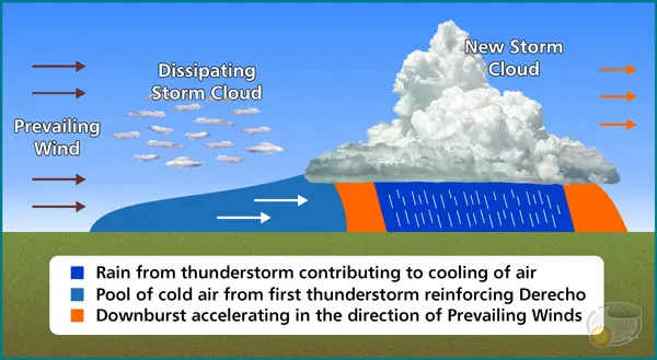
New thunderstorm and pool of cold air reinforce Derecho. Click on image for a larger view.
The warm, humid air that has been lifted by the cold winds ahead of the storm front starts to cool down, and condensation takes place, which can result in the formation of an entirely new thunderstorm.
As the newly formed storm matures, another column of cold air develops and eventually drops to the ground. As a result, the pool of cold behind it already present from previous storms get reinforced by fresh downbursts from the new thunderstorm.
It becomes clear how this process can keep on repeating itself under the right conditions, gain momentum, and grow in size and strength. Under these conditions, the bow-shaped storm front that is so synonymous with Derechos, called a bow echo, develops.
This repetitive process is what makes it possible for Derechos to travel for hundreds of miles and cause so much destruction over such a widespread area.
At the leading edge of the storm front, distinctive-looking clouds called shelf clouds (also known as arcus clouds) form, which is as spectacular as they are ominous looking. They are as synonymous with Derechos as the bow echoes these storm systems produce.
Characteristics And Effects Of Derechos
The effect a derecho has on any region it impacts is comparable to a number of other extreme weather events like tornadoes and hurricanes. It is therefore not surprising that this storm system often gets confused with other weather events.
There are two characteristics of a derecho, though, that sets it apart from other storms and makes it so unpredictable and dangerous…
Surprise Element Of A Derecho
With most extreme weather events, there are some identifiable buildup or accompanying weather conditions that give meteorologists a fair amount of time to provide potentially affected regions with weather alerts of an approaching storm system.
Hurricanes can be tracked from their origins over the warm waters of the Subtropics and their path can be calculated with forecasting models. The buildup of supercells that have a high probability of tornadoes occurring can also be identified with Doppler radar systems.
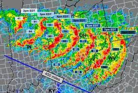
Radar image showing the development and scope of bow echos that are so synonymous with a derecho.
Although Derechos are widely recognized today, and weather conditions conducive to their formation are identified, they remain unpredictable and can seem to strike out of nowhere.
Hurricane strength winds, sometimes followed by a downpour of rain, can catch an entire region completely off-guard and hit without any visible warning. Although it moves through an area fairly rapidly, it can cause widespread damage and injuries in a short period.
It is this “surprise element” that is so characteristic of a derecho that makes it so dangerous and potentially deadly.
(Even experienced meteorologists can identify the conditions favorable for a derecho to form and signal a weather alert, but they won’t know for sure until it actually happens. It is part of what makes predicting this type of storm so tricky.)
Sheer Size And Scope Of Affected Regions
The second characteristic that sets a derecho apart from other storms is the sheer size of the area affected. As prevailing winds move a grouping of a thunderstorm in the same direction and form a singular weather event, it has a widespread effect.
The fact that a weather event needs to be at least 400 kilometers (250 miles) wide to be classified as a derecho already points to the scale of the storm. In many cases, Derechos far exceed this minimum requirement.
Under favorable conditions, this storm system can also build momentum and travel for hundreds of miles. The damage on this scale can not only be measured in injuries or loss of life but overall costs as well, which can run into hundreds of millions of dollars.
(The derecho that occurred during June 2012 in the Mid-Atlantic and Midwest of the United States resulted in damage estimated to be in excess of 2.9 billion dollars.)
Wind Damage And Flash Flooding
The majority of destruction and injury caused by Derechos is the result of powerful winds and flash flooding that occur during the storm.
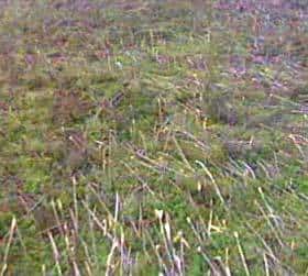
Widespread destruction of trees by a Derecho weather event.
The sudden arrival of strong winds without any (or little) warning can cause severe damage to any region. Trees, power lines, and lamp posts, etc., can be completely flattened and structures severely damaged with winds reaching speeds of up to 160 km/h (100 mph).
When enough moisture is present in a group of thunderstorms, and it moves slowly enough over an area, flash flooding can occur. A region’s topography with steep slopes and valleys can also result in the quick buildup of water, which can trigger flash floods.
Apart from the damage to structures and the environment, people caught outside or in nature carry the highest risk of getting injured or worse. The majority of fatalities caused by Derechos are as a result of people being struck by fallen trees/objects or drowning.
The widespread downing of power lines can also result in the loss of power to millions of homes and have a substantial impact on the region’s economy. (The derecho of June 2012, mentioned earlier, caused a power outage to 4.2 million users over multiple states.)
Conclusion
What is clear from this article is that even though most people are not aware of its existence, a derecho is a powerful and widespread storm system. (Even though there is still a debate among meteorologists around the specifics of this phenomenon.)
The argument can be made that a derecho is just the sum of thunderstorms working in unison under the right conditions. But the same can be said about a thunderstorm or tornado that is also the result of individual mechanisms operating in the right environment.
This article explained what a derecho is and how it forms. It also looked at its characteristics and some of the most significant impacts it has on human life and the environment.
Never miss out again when another interesting and helpful article is released and stay updated, while also receiving helpful tips & information by simply clicking on this link .Until next time, keep your eye on the weather!
This article was originally published on ownyourweather.com. If it is now published on any other site, it was done without permission from the copyright owner.

