Surface winds caused by temperature gradients and topographical changes are well-known weather phenomena, but the impactful upper atmospheric winds, known as jet streams, are lesser-known.
Jet streams are defined as narrow bands of strong upper atmospheric winds close to the edge of the troposphere, traveling at high speed from west to east. These permanent winds form due to temperature differences between warm and cold air masses and circumvent the Earth, following a meandering path.
We don’t experience or see the direct impact of these powerful winds, but they are essential for the creation of weather systems across the world. They are so influential that one can go as far as stating that a large number of major weather events cannot occur without them.
These winds are called jet streams and occur in specific regions at different heights around the globe. But what are these powerful winds, and how do they form?
In this post, we take a look at what a jet stream is and how it forms. We also examine its effect on weather systems.
Jet Stream Definition
Before we can examine how jet streams are formed and look at their effect on the weather, we need to define what a jet stream is first:
What Are Jet Streams?

Jet streams are narrow bands of strong upper atmospheric winds close to the tropopause, traveling at high velocities from west to east. These permanent winds form due to temperature differences between warm and cold air masses and circumvent the Earth, following a nearly straight or meandering path.
These phenomena are referred to as narrow bands (or ribbons) of wind since they are hundreds of kilometers in width but only a few kilometers in depth.
Although relatively stable in their position, they can move more to the south or north, depending on the season, and influence the weather conditions below them during the process.
Types Of Jet Streams
The atmosphere contains two primary jet streams:
- Polar Front Jet
- Subtropical Jet
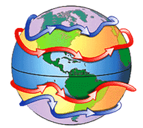
Both the Northern and Southern Hemisphere have a polar and subtropical jet stream, creating four permanent jet systems in total surrounding the Earth. Both types of jets are created by a difference in temperature between two air masses.
Smaller, temporary jet streams also exist. African Easterly and Somali Jets are two of the better-known ones. Other occurrences include barrier and valley exit jet streams. They are not nearly as influential as the two primary systems, though, which will be our focus.
How Are Jet Streams Formed?
Both Polar Front and Subtropical Jets are formed in the same manner. There are subtle differences, though, which is why each system’s formation and characteristics should be looked at separately to avoid any confusion.

Formation of the Polar & Subtropical Jet Streams in the Northern Hemisphere
The Polar Front Jet Stream And How It Is Formed
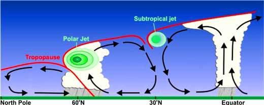
The polar front jet stream occurs at 60 degrees north and south of the Equator at heights of 9 – 12 kilometers (30 000 – 39 000 feet) in the troposphere. The wind speeds can reach and exceed 321 km/h (200 mph).
The Northern Polar Jet sits above the polar front and is the result of the temperature difference between the cold Arctic air and warm tropical air. As the two air masses meet, the difference in air pressure between them produces what is called a pressure gradient force.
(Air always flows from a high-pressure area to a low-pressure area. The warm tropical air has a much higher air pressure than the cold air from the North and South Poles, hence the strong pressure gradient force.)

The Coriolis Effect, deflecting winds to the right in the Northern Hemisphere and to the left in the Southern Hemisphere
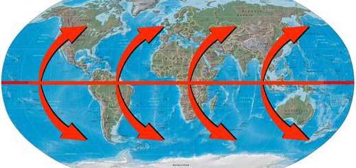
In the Northern Hemisphere, one would assume the strong pressure gradient will cause the warm tropical air to flow northwards towards cold air over the poles. However, The Coriolis Effect forces the air to be deflected to the right.
In the Southern Hemisphere, the deflection is towards the left. As a result, a polar jet is a strong wind that is created along the border between the two different air-pressure masses, flowing parallel to the pressure gradient from west to east.
The Southern Polar Jet has the same characteristics as its northern counterpart and is created in the same way. Unlike the Northern Polar Jet, though, it follows a fairly consistent clockwise path around the Antarctic and does not shift or meander as much.
Since Antarctica is also far removed from any other landmasses and populated regions, the amount of seasonal north-south shifting in the jet stream will have very little, if any, significant effect on any human or plant life, as well as the environment.
The Subtropical Jet Stream And How It Is Formed
The subtropical jet stream occurs at 30 degrees north and south of the Equator. It is slightly weaker and forms at higher altitudes than the polar jet and can be found at heights of around 10 – 16 kilometers (33 000 – 52 000 feet.)
The subtropical jet in the Northern Hemisphere is also a result of a strong pressure gradient that is created by the temperature difference between the warm air from the tropical region and the colder mid-latitude air.
Due to the strong temperature gradient and the deviation to the right due to the Coriolis Effect, a strong band of wind flowing westward is created, The Subtropical Jet Stream.
Keep in mind that the formation of a jet stream involves complex processes, and the ones described here are simplified explanations to make these phenomena easier to understand. It still manages to capture the essence and accurately portray the basics of these systems.
How Does The Jet Stream Affect Weather?
To say that jet streams affect the weather is a mild understatement. They create and are the main driving forces of numerous major weather systems, as well as seasonal weather change across the world.
To name every possible event and occurrence that is either directly created or influenced by these powerful upper-atmospheric winds would be impossible and take up a whole encyclopedia. We will focus on the most important ways in which jet streams affect weather.

Chicago in an icy grip as Rossby waves in the Polar Jet Stream meander south
During winter in the Northern Hemisphere, colder air over the Arctic shifts the polar jet south, bringing cold & wet weather to Northern Europe and the United States. During summer, the opposite occurs as warmer air from the Tropics moves into the region.
Jet streams do not follow a straight line but tend to follow wave-like and winding flows. These meandering flows are called Rossby waves, which are the result of variations in the Coriolis Effect and the underlying topography on the planet’s surface.
Rossby waves have a big effect on the weather of a region, as the dips and peaks in the waves bring entirely different weather to an area. Depending on its speed, Rossby waves can last for a short or very long period, enabling it to even affect climate patterns.
Jet streams also influence aviation. Due to its strong wind speed, airlines make use of it to reach their destinations faster with less energy. Flying against it must be avoided for obvious reasons, which is why airlines keep a close eye on the position of jet streams.
The effect of jet streams is a lot more widespread than the few examples highlighted in this section, but these examples will help to explain how influential these powerful phenomena are in affecting weather globally, as well as the number of conditions it impacts.
Conclusion
As this article clearly illustrates, jet streams are one of the most crucial components in the formation of global weather patterns. They are formed in complex ways, and the explanations provided in this post were fundamental but not enough to make it totally understandable.
In this article, we focused on explaining what a jet stream is and how it forms. The post also examined the different forms of jet streams and how each one is created.
Never miss out again when another interesting and helpful article is released and stay updated, while also receiving helpful tips & information by simply clicking on this link .Until next time, keep your eye on the weather!

